Home
City Centre
Connecting Sheffield: City Centre
Overview
Connecting Sheffield: City Centre is a key part of the ongoing transformation of the city centre.
It will improve our public space and streets to create an attractive place for people to spend time, including more space which provides the opportunity for outdoor seating at cafes and restaurants to make city centre a vibrant destination.
More people are living and working in the city centre, so we need to develop our transport infrastructure to enable people to access work, education and leisure opportunities.
The scheme proposals will create new green spaces and build on the opportunities for people to walk, wheel (using wheelchairs, pushchairs and mobility scooters), cycle and travel by bus across the city centre.
The project will:
- create open, attractive places and spaces in the city centre where people want to stop, relax and spend time.
- Reduce bus journey times across the city centre and improve reliability, making the bus a more attractive choice for people.
- Create direct, safe and attractive walking, wheeling and cycling routes through the city centre.
- Enable more people to walk, wheel and cycle, creating a safer, more vibrant and less polluted environment for city living.
- Link the improvement works on Fargate, developments at the Heart and The Moor, continuing the development of our thriving city centre.
- Bring the Outdoor City into the city and encourage visitors, commuters and residents to enjoy the outdoor elements of the city centre by creating green streets with high-quality planting and landscaping. We'll also integrate sustainable urban drainage to slow the flow of water and reduce the risk of flooding.
The visualisations the city centre scheme have been updated so that they continue to represent the diversity of Sheffield's communities
Changes to the design following consultation
We consulted on the initial scheme plans in 2021. We’ve developed our plans, taking on board the findings from the consultation, as well as further engagement with accessibility groups, cycling bodies and other groups who would be affected by the proposals. You can view the full consultation report here.
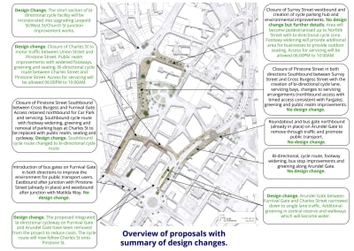
We’ve highlighted the key changes to our proposals on the map. These include:
- Widening the footway from Cross Burgess Street to The Moor create more space between pedestrians and cyclists.
- Pedestrianising Surrey Street between Pinstone Street and Norfolk Street, which will create more space for events and opportunities for more outdoor seating for businesses. This will also include a cycle route which connects to the proposed cycle routes on Fargate and Pinstone Street.
- We will pedestrianise Charles Street between Pinstone Street and Union Street, again offering the opportunity for more outdoor seating space for businesses.
- We have removed the segregated two-way cycle route we previously proposed along Furnival Gate and Arundel Gate close to Furnival Gate Roundabout.
- We will still construct a two-way cycle route between Sheffield Hallam University to where Pinstone Street meets Furnival Gate, but this will now run from Howard Street to Charles Street then via Pinstone Street.
As costs have increased since we designed our original proposals, the scheme now concentrates on the primary routes along Pinstone Street and Arundel Gate. This provides a seamless connection between the current improvements on Fargate and the top of The Moor.
Updated Proposals
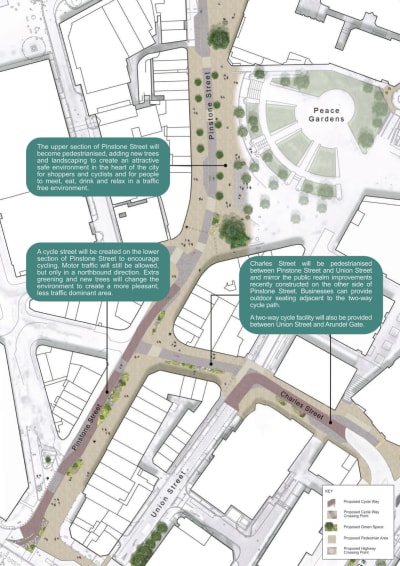
Leopold Street - Surrey Street - Pinstone Street (North)
We’ve kept the primary improvement proposals to provide a high-quality route through the city centre to link Pinstone Street to the ongoing improvement works on Fargate. This provides the key link between the Heart of the City development and The Moor, paving the way for our thriving city centre. Closing Pinstone Street to motor vehicles will expand the event space near the Peace Gardens creating a vibrant and more pleasant environment for people to shop, eat, drink or relax. These improvements will also complement the new Radisson Blu hotel which is due to open in the summer this year.
Increased pavement space means commuters and visitors can browse and travel through the area easily. It will also create outdoor space that provides an opportunity for cafes and restaurants to use for outdoor seating.
We will also pedestrianise Surrey Street and Charles Street ,which will include two-way cycle route to connect existing and proposed cycle routes.
We will install moving bollards where Surrey Street joins Norfolk Street, and also on Pinstone Street near Cross Burgess Street. We’ll maintain access for deliveries between 6pm and 10am.
We’ll also accommodate drop offs for weddings and VIP visitors to the Town Hall by changing the parking bay on Barkers Pool from ‘police vehicles only’ to ‘permit holders’ for special events.
We are reviewing on-street parking in the core of the city centre with a view to creating more disabled parking close to key locations. We propose to provide more disabled parking spaces on Leopold Street and Union Street to replace the ones we’ll remove on Surrey Street and Charles Street. Prioritising on-street parking close to shops and services for disabled parking spaces is important to ensure the city centre is accessible to everyone.
Leopold Street - Surrey Street - Pinstone Street (North) plan
Pinstone Street
The extension of the cycle route along Pinstone Street to Cross Burgess Street will link to the improvement works on Fargate and the developments at the Heart of the City.
We will not add the cycle route along the footway at the top of The Moor, but cyclists will still be able to link to Charter Row and Pinstone Street using the traffic signal junction at the bottom of Pinstone Street. This is to keep enough space for pedestrians and cyclists in a busy area.
Pinstone Street plan
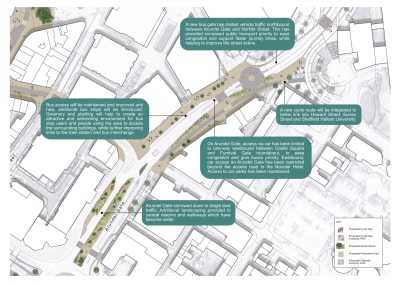
Arundel Gate between Charles Street and Sheffield Hallam University
We will install a new roundabout outside the Novotel Hotel to provide an easier route back from the bus gate between Arundel Gate and Norfolk Street for traffic that can’t pass through. We’ll maintain access to the multi-storey car park too.
We’ll create a two-way cycle route along the south side of Arundel Gate segregated by landscaping which will link the cycle route at the Sheffield Hallam University campus to Charles Street. We’ll install a cycle crossing to link to the cycle route on Charles Street.
Arundel Gate between Charles Street and Sheffield Hallam University plan
Revised bus routes and new bus facilities
Much of the bus service re-routing in the city that we proposed is now in place. The bus gate on Furnival Gate out of the city is in place, along with the bus gate between Arundel Gate and Norfolk Street.
We plan to install another bus gate into the city on Furnival Gate between Matilda Way and The Moor. By reducing traffic in these areas, we can contribute to improving air quality and improve access for public transport.
The proposed works on Rockingham Street have not changed but construction was brought forward building on the success of Pound’s Park and tie in with Kangaroo Works both completed in December 2023. Works on Rockingham Street are due to be completed in the summer which will include the installation of new bus shelters with real-time information creating a ‘mini bus hub’ on the street.
The current routes for buses into and across the city centre will remain in place. We only propose minor changes for buses accessing the city centre via West Street.
Instead of using Carver Street – Division Street – Rockingham Street, we will change the junction of West Street and Rockingham Street to allow buses to turn into Rockingham Street to provide a quicker, more direct route. Rockingham Street, which is currently one-way when travelling from Division Street towards West Street, will be made two-way and a bus gate will be introduced between Devonshire Lane and Wellington Street, to allow access for buses travelling towards Charter Row only. We will retain access to all premises on Rockingham Street. These changes are planned for implementation in the summer.
We will install new bus shelters with real time information on Arundel Gate (near the Crucible) and Rockingham Street this summer.
Coming soon – travel to more places for free on the new zero-emission Sheffield Connect
In 2022 we introduced, with the South Yorkshire Mayoral Combined Authority, the Sheffield Connect bus service. The SC1 service links 12 stops in the city centre, connecting The Moor, Arundel Gate, Sheffield station, the Interchange, Sheffield City Hall and Rockingham Street, helping people access key locations easily.
From Monday 8 April bus users in Sheffield will be able to enjoy their journey around the city centre in the comfort of a brand new, zero emission bus.
And that’s not all.
Not only is the service going electric, the Sheffield Connect will also become a completely free service for everyone to use seven days a week across the core of the city centre. The SC1 will run up to every seven to eight minutes, so you can just turn up and go.
And a new second route, the SC2, will run from Monday 8 April too. Running every 20 minutes, this new route will also be completely free to use and zero-emission. It will connect The Moor, Arundel Gate, the Interchange, Castlegate and West Bar.
You can find out more about the routes and the service by visiting the Travel South Yorkshire website.
Check out the following documents