Home
Darnall-Attercliffe-City Centre
Darnall-Attercliffe-City Centre
Update 10 June 2024
Surveys have recently taken place along the Darnall-Attercliffe route to understand the number of people that currently walk and cycle at various points along the scheme. The surveys will help shape how an active travel scheme could look. We will only use the footage we capture to determine numbers, we won’t record any personal information like faces or number plates.
This data collection exercise is one of the first stages of the project that will include further local consultation and engagement on the designs later-on in the year.
Introduction
Consultation on Darnall-Attercliffe-City Centre ended on 19 April 2021.
You can now view the consultation report for this scheme here . You can also view a shorter Executive Summary here.
Connecting Sheffield: Darnall–Attercliffe-City Centre is a planned cycling, walking and public transport infrastructure scheme being brought forward under Connecting Sheffield, a new approach designed to transform travel, alongside complementary environmental improvements. We are now consulting on our proposals for this scheme and would like to hear your views.
The Lower Don Valley is regenerating and has become an important employment and leisure area. An area stretching between the centres of Rotherham and Sheffield is now described as the Advanced Manufacturing Innovation District (AMID), with the Lower Don Valley at its heart.
Darnall and Attercliffe are experiencing significant growth in new housing, and new educational facilities have opened in recent years. There are several major leisure and sports centres in the area including Sheffield Arena, iceSheffield, the English Institute of Sport, and the Sheffield Olympic Legacy Park.
Connecting Sheffield: Darnall–Attercliffe-City Centre has been designed to transform access between these growing employment, leisure and housing opportunities in Darnall, Attercliffe and the Lower Don Valley into the City Centre and to Meadowhall, which will make the area more attractive to live, work and invest in.
The scheme would feature high-quality, largely segregated cycle routes, improved walking infrastructure and bus priority measures to improve reliability and journey times. Where possible, we would look to introduce environmental improvements such as new planting.
The current proposals would require the removal of 15 small semi-mature trees: 12 by iceSheffield, 2 by the English Institute of Sport and 1 by the Olympic Legacy Park to make room for the footway and cycle track. Replacement trees would be planted in the same area with an additional 22 tress proposed elsewhere along the scheme's extent. The species of trees and locations for planting will be confirmed with the help and advice of the Sheffield Street Trees Partnership.
Click here to see a map showing the full extent of this scheme. More detailed maps of key areas where changes are proposed are provided further down this page.
Cycling and Walking Proposals between the City Centre and Attercliffe
The improved cycling and walking connections would start in the City Centre at Castlegate on Exchange Street and continue along Furnival Road and across the inner ring road to connect into a new segregated cycle route. To achieve this, the movement of vehicle through-traffic along Furnival Road, crossing the inner ring road, would be prohibited, replaced with a dedicated cycle track. The left turn out of Furnival Road onto Derek Dooley Way would also be prohibited. This would provide a traffic free route connecting into the start of the segregated cycling route along Furnival Road. New planting would also make this area more attractive. Exit from Furnival Road would instead be via Exchange Place and Park Square roundabout.
In the city centre, the route would connect from Furnival Road into the existing cycle route running along Castlegate and Bridge Street up to West Bar and the cycle route that forms part of the Connecting Sheffield: Neepsend–Kelham-City Centre scheme. In the future, the cycle route would be expanded further into the city centre beyond Exchange Street to connect into the Connecting Sheffield: City Centre scheme at Arundel Gate and the proposed measures as part of the Future High Streets Fund work being taken forward to improve Fargate and High Street.
The map below illustrates the measures proposed along this first stretch of the route, from the inner ring road outbound:
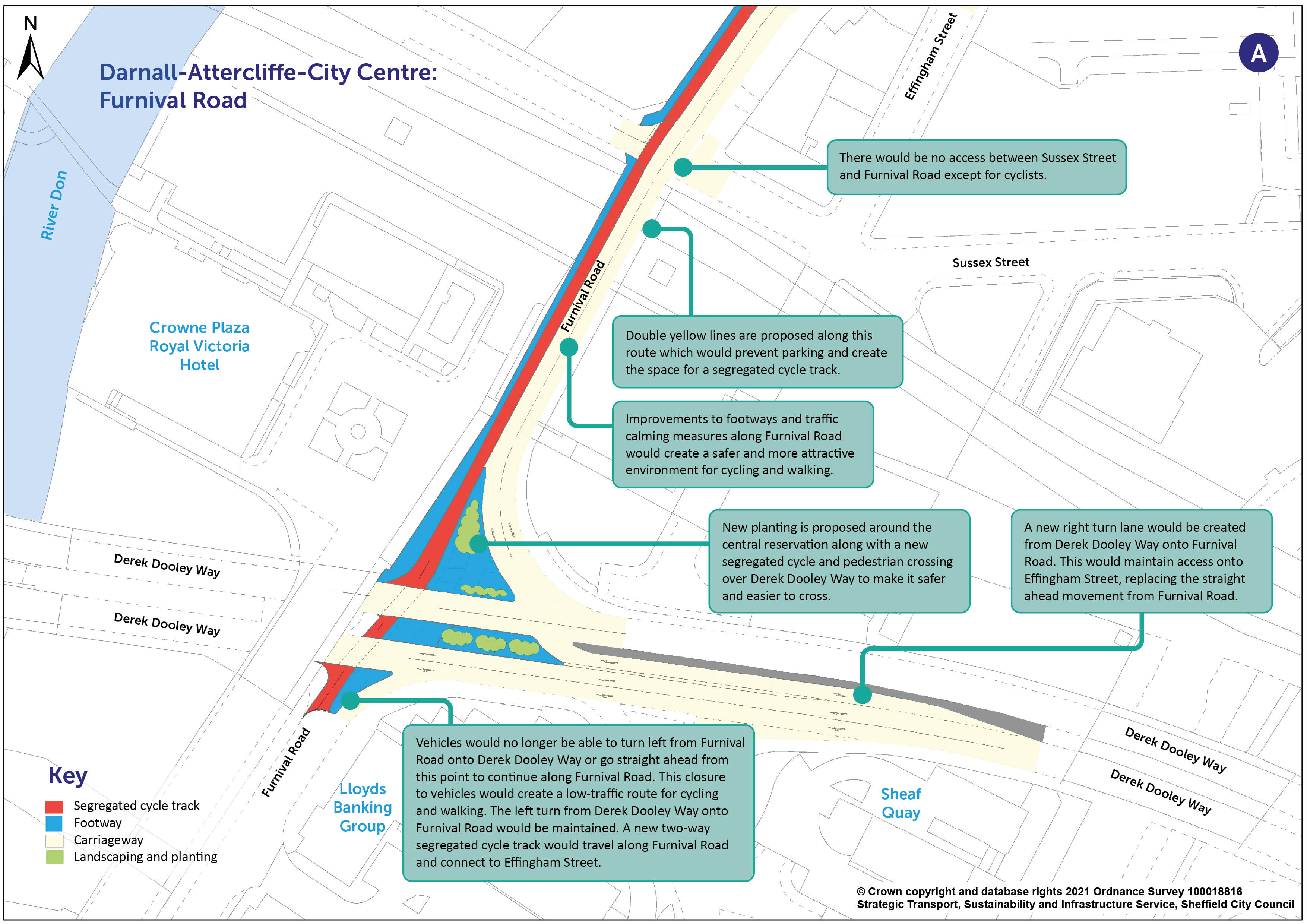
You can view a pdf of the above map and zoom in by clicking here .
From Furnival Road where the segregated cycle track would start, the route would continue along Effingham Street and Foley Street, allowing it to bypass a section of Effingham Road up to the Effingham Road/Bernard Road roundabout. To accommodate the new cycle track, parking would be removed along the north side of Effingham Street and traffic calming measures would be introduced to improve safety for all users. Continuing along Effingham Road from the roundabout, the segregated cycle route would continue to Attercliffe Road via Lovetot Road. These proposals are shown on the map below.
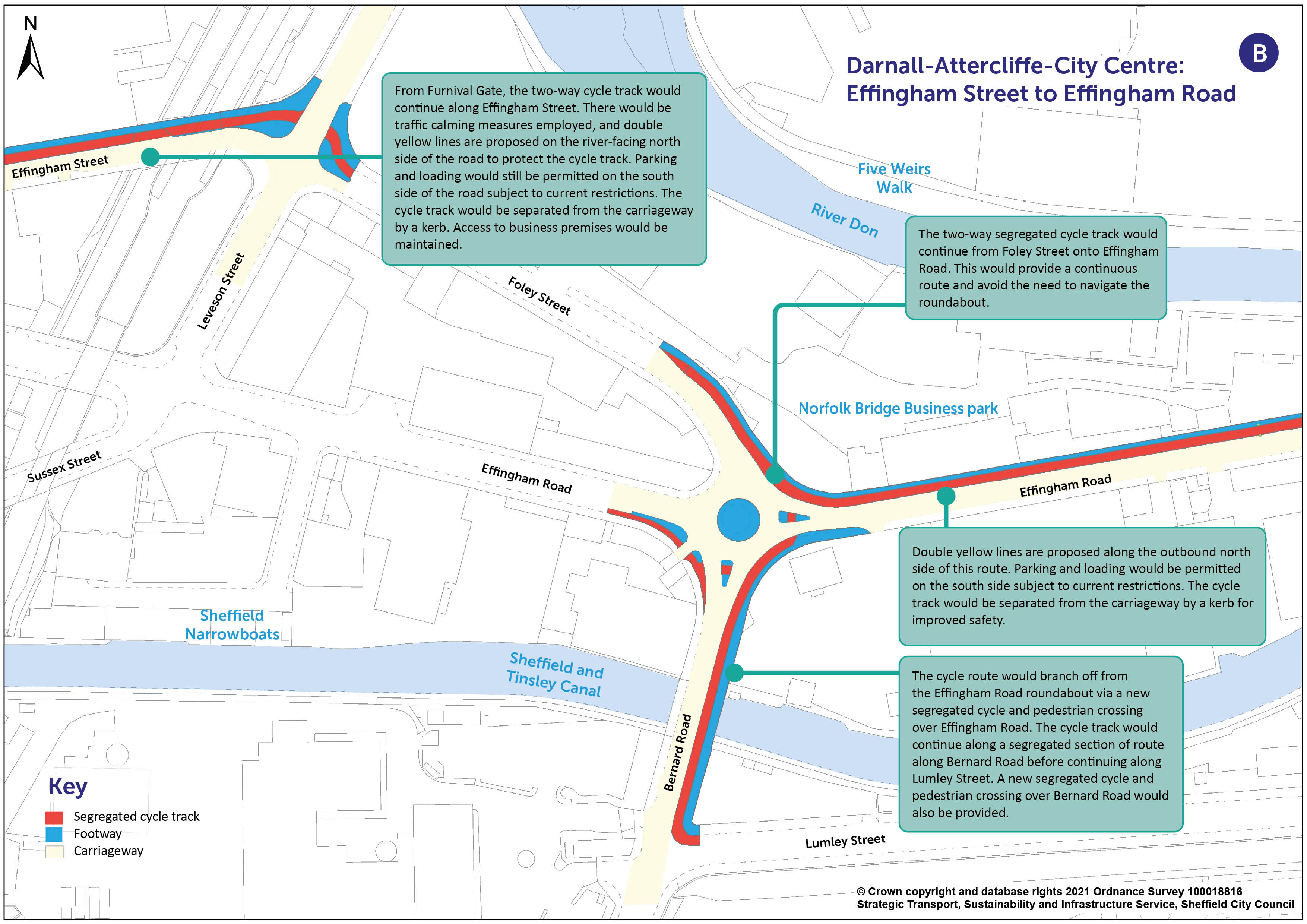
You can view a pdf of the above map and zoom in by clicking here .
Cycling and Walking Proposals through Attercliffe
The largely segregated cycle route would continue along Attercliffe Road from the junction with Effingham Road through Attercliffe Centre and right up to Arena Square Roundabout.
A second cycle route between Woodbourn Road and the Effingham Road/Bernard Road roundabout is no longer being progressed as part of this scheme. Opportunities are to be sought about how to best tie in the Attercliffe Waterside development with the Connecting Sheffield: Darnall-Attercliffe-City Centre scheme.
Along Attercliffe Road, where feasible, side streets would have a continuous cycle track across the junctions. Vehicles would still have full access, but where continuous cycle tracks are employed, cyclists would have priority over traffic turning into and out of side roads .
To achieve this, the cycle tracks would run continuously across junctions at the same level as the pavement, and road traffic would travel over a ramped area. This would slow down traffic to enhance safety.
Continuous cycle tracks are based on an approach applied in The Netherlands which gives priority to cyclists across side road junctions.
The visualisation below illustrates how this works:
A new 20mph speed limit would be introduced along the route of the segregated cycle track on Attercliffe Road, through Attercliffe centre between the junctions of Effingham Road and Worksop Road. To create the required space for the segregated cycle track and improve safety, reduce congestion and improve journey times for buses, a red route is proposed along Attercliffe Road between the junctions with Effingham Road and Janson Street and also along Worksop Road to the junction with Leeds Road. A red route prohibits parking, loading and waiting. These new restrictions would be communicated by red double lines and signage and would be enforced by camera.
As an alternative to loading on Attercliffe Road and Attercliffe Common, loading would instead be enabled by loading bays and double yellow lines (on which short term loading is allowed), added to side roads off Attercliffe Road.
The map below shows a section of Attercliffe Road to highlight some of the key changes being proposed.
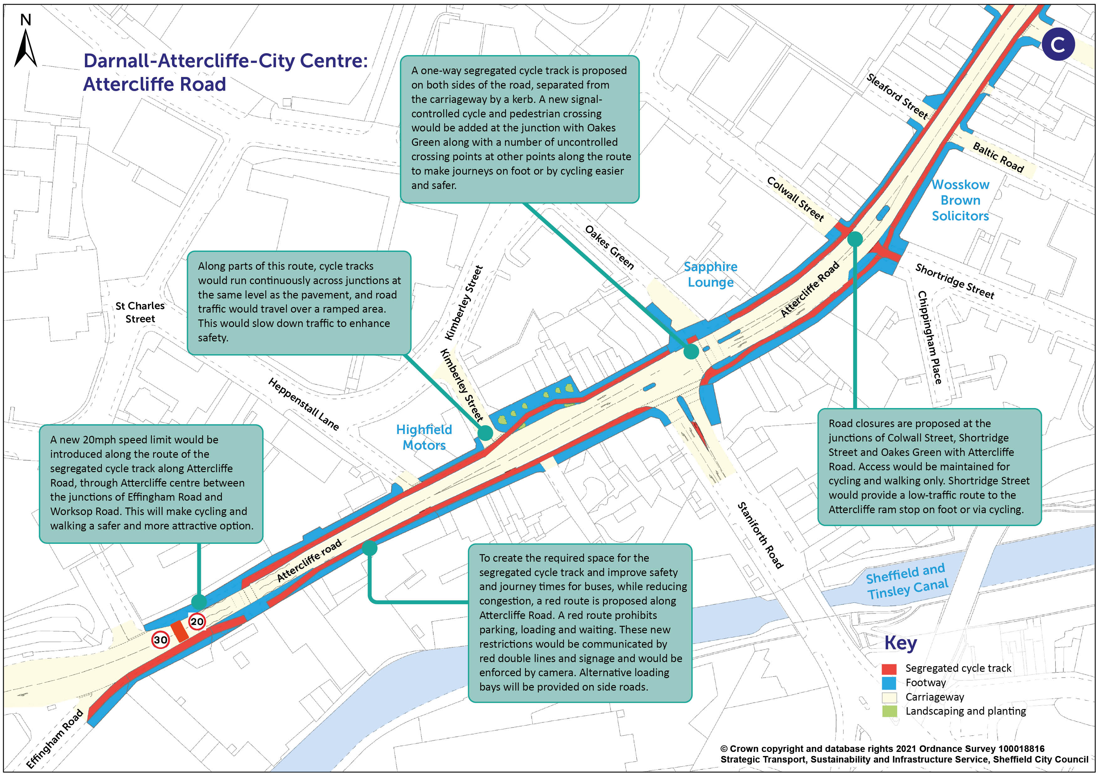
You can view a pdf of the above map and zoom in by clicking here .
The photomontage below provides an indicative visualisation of Attercliffe Road where significant improvements for cycling and walking are being proposed. The slider can be moved to show the viewpoint at present compared to the viewpoint after the scheme is delivered.
The segregated cycle track would continue along Attercliffe Road through the centre of Attercliffe. The map below shows the measures being proposed through Attercliffe Centre.
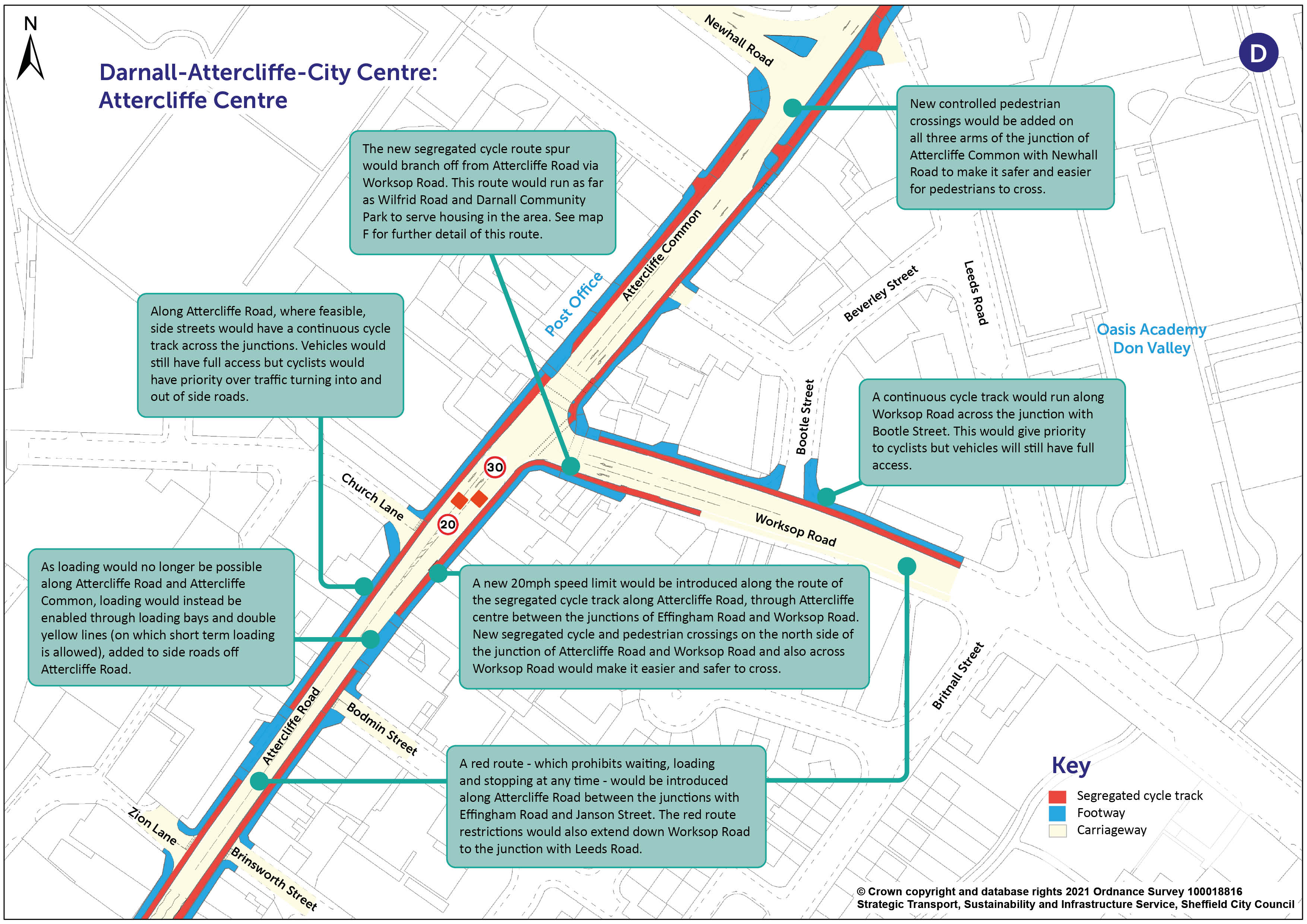
You can view a pdf of the above map and zoom in by clicking here .
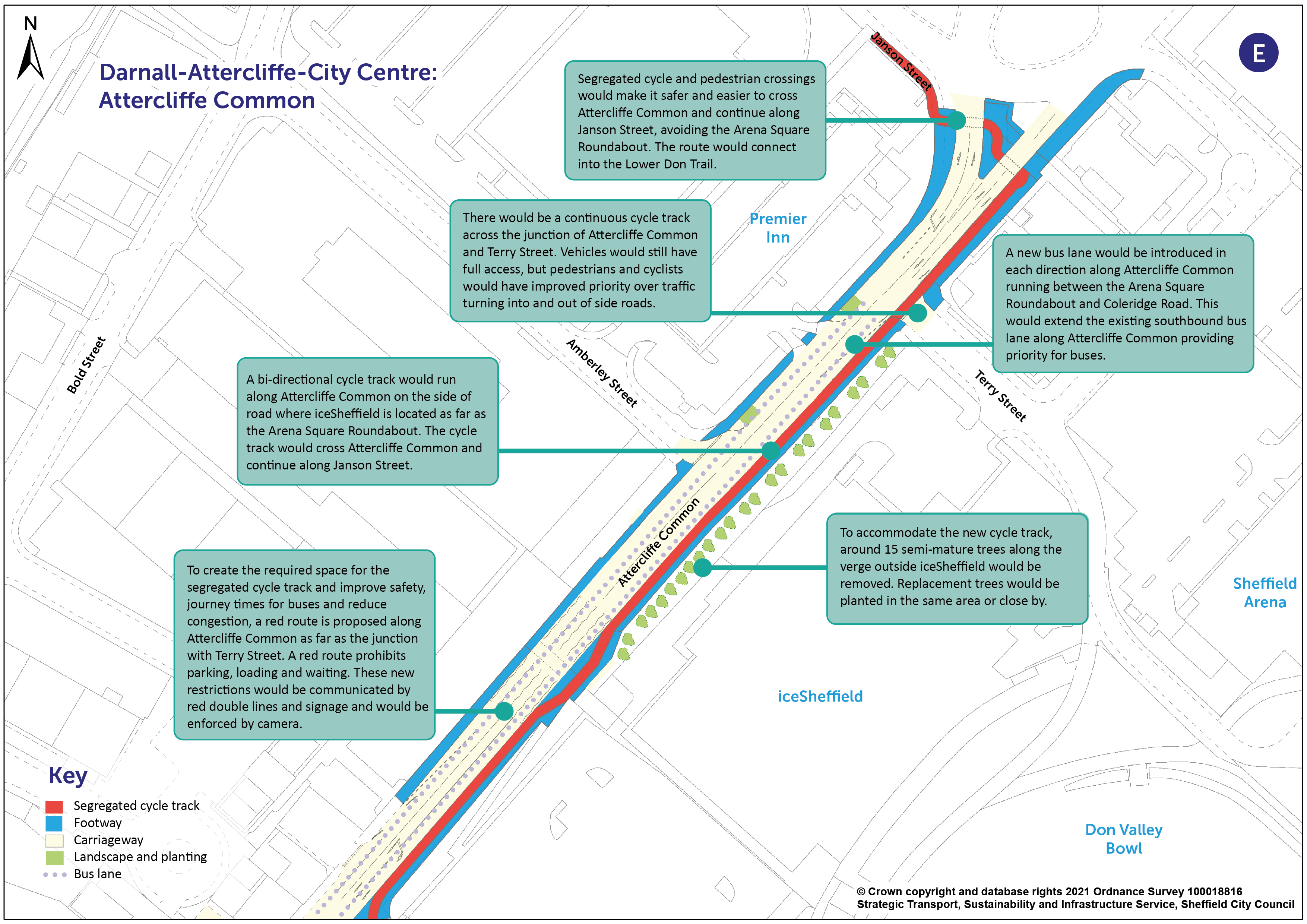
The cycle route would continue along Attercliffe Common as far as the Arena Square roundabout. Improvements to public transport infrastructure would also be made along this stretch and are detailed further down this page. There would be improved pedestrian and cycle crossing facilities in Attercliffe and at the Arena Square roundabout to help people to connect into the leisure facilities in this area and into the existing cycle route to Meadowhall, and the newly proposed Connecting Sheffield: Magna-Tinsley cycle route from Meadowhall through to Magna Science Adventure Centre.
The map below shows the measures being proposed along Attercliffe Common.
You can view a pdf of the above map and zoom in by clicking here .
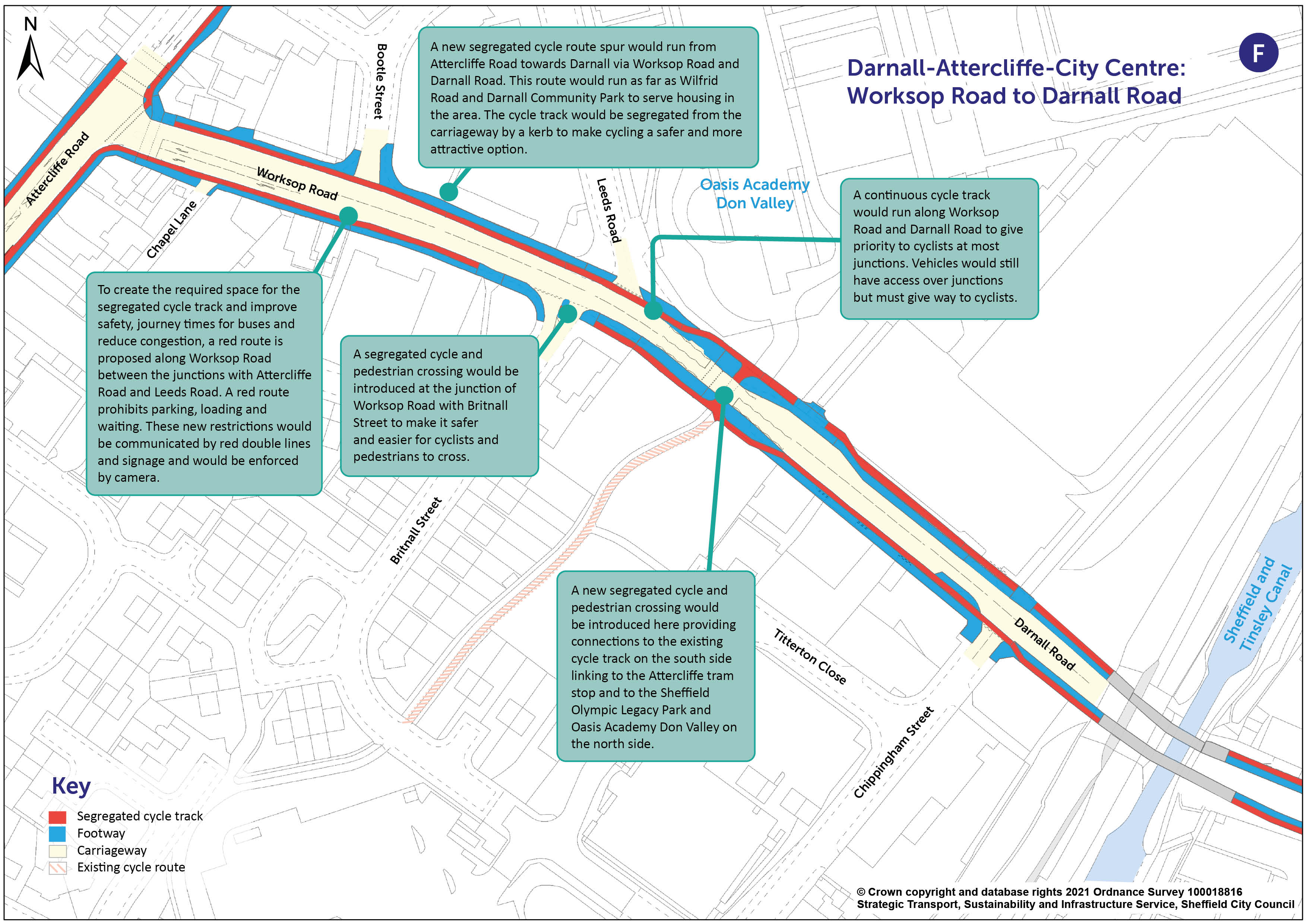
Cycling and Walking Proposals for Darnall
A new segregated cycle route spur would run off the Attercliffe Road cycle route to Darnall via Worksop Road and Darnall Road. This route would run as far as Wilfrid Road and Darnall Community Park to serve housing in the area.
The map below shows measures being proposed along this stretch of the route.
You can view a pdf of the above map and zoom in by clicking here .
This route would be designed to allow a potential future extension to Greenland Road, with a further possible subsequent extension via Catley Road offering the opportunity of connecting into the Advanced Manufacturing Research Centre (AMRC), subject to available funding.
A second complementary cycle route would also serve Darnall, branching off the Attercliffe Road segregated cycle route at Shortridge Street and at Shirland Lane. A closure to motor vehicles is being proposed at the junction of Attercliffe Road and Shortridge Street along with some parking restrictions along this road to create a low-traffic area for cycling and walking between Shortridge Road and Shirland Lane. From here, the route would connect into the Attercliffe tram stop.
Connecting low-traffic areas where cycling and walking are safer and more attractive, the cycle route would run along the length of Shirland Lane to the junction with Staniforth Road to connect into the low traffic areas leading from Watkin Close and into the wider Darnall community. Measures to support the introduction of the new cycle route would include some parking restrictions along Shirland Lane and the closure of the bridge at Shirland Lane to through-traffic. The route would connect to the segregated Darnall Road cycle route via Wilfrid Road, which would see traffic-calming measures introduced. A high-quality crossing would be installed at the junction of Shirland Lane and Staniforth Road to allow people to safely connect into the residential area south of Staniforth Road.
Walking infrastructure would be improved along the Connecting Sheffield: Darnall-Attercliffe-City Centre route at key locations. Measures would include improved crossing facilities and improved paving.
Changes to parking and junctions
Detailed information on the proposed changes to parking and junctions along the entire Connecting Sheffield: Darnall-Attercliffe-City Centre route can be found here .
Improved Public Transport Infrastructure
Data shows that around two thirds of people who live between the city centre, Attercliffe and Meadowhall travel less than 10km to work by car rather than walking, cycling or public transport. Alongside improved cycling and walking facilities, bus priority measures are also proposed to reduce car dependency for shorter distance journeys.
Delivering bus priority measures to improve reliability and journey times would enable more people to choose buses as a preferred way to travel to work in the area and provide a realistic alternative to car travel. Bus lanes also provide priority for taxis, cycles and motorcycles.
In the original plans we consulted on, we proposed to install a bus lane on Meadowhall Road towards Meadowhall Interchange. We have done traffic modelling on this and it showed that the bus lane would not significantly benefit buses and would impact general traffic and the M1 Junction 34. So we have decided that we shouldn’t take this part of our plans forward and will remove it from the project.
A new bus lane would be introduced in each direction along Attercliffe Common running between the Arena Square Roundabout and Coleridge Road at the English Institute of Sport. This would extend the existing southbound bus lane along Attercliffe Common providing priority for city-bound buses on the approach to the Newhall Road/B6083 junction. A new northbound bus lane would also run between Coleridge Road and Janson Street to improve outbound journeys. These measures would enable bus services to avoid delays on this busy section of road.
The photomontage below provides an indicative visualisation of Attercliffe Common outside iceSheffield and highlights the bus lane alongside the proposed cycle route detailed earlier. The slider can be moved to show the viewpoint at present compared to the viewpoint after the scheme is delivered.
A section of bus lane would also be introduced in the Handsworth area to improve bus journey reliability and journey times on the busy 52 bus route. The bus lane would be located along Handsworth Road in a south easterly direction, outbound from Clifton Crescent to the approach to the junction with Sheffield Parkway. There would also be improvements to prevent queueing on the approach to Greenland Road which would improve bus journey times. Around 25 bus stops would be upgraded; locations are to be confirmed.
------------------------------------
To help us to monitor the success of this project we may need to occasionally survey traffic in the area using cameras mounted on lamp posts. We need to do this so that we can understand how traffic has been affected by the scheme. For example on certain roads we may wish to understand whether traffic has reduced or increased as a result of the scheme.
If you have any queries, concerns or complaints about the way Sheffield City Council processes your personal data, including the way we handle information requests, you can contact our Customer Services or the Data Protection Officer.
If you are not satisfied with our response or believe we are not processing your personal data in accordance with the law you have the right to contact the Information Commissioner’s Office.
This engagement phase has finished

...