Home
Magna - Tinsley
This page has now moved to https://haveyoursay.sheffield.gov.uk/connecting-sheffield-magna-tinsley on our new Connecting Sheffield hub. Please check there for the latest updates on Connecting Sheffield: Magna - Tinsley
Magna - Tinsley latest updates
Work to start on the Sheffield Road crossing near Raby Street
Work is due to start on the Connecting Sheffield: Magna – Tinsley project. Our contractor, Amey, will start from Thursday 18 April 2024 to build a new crossing for pedestrians and cyclists on Sheffield Road by the junction with Raby Street.
During construction, we’ll need to install temporary traffic lights to operate on Sheffield Road on either side of the junction with Raby Street. There will also be no access to and from Raby Street from Sheffield Road during the works to allow space for the work to safely happen. We will have the following diversions from Raby Street in place:
- To and from M1 Junction 34 South: via Bawtry Road and Norborough Road
- To and from Rotherham (Sheffield Road): via St Lawrence Road
You can see the diversion routes on the map below.
Sheffield Road and Raby Street diversion routes during works to install the crossing on Sheffield Road near Raby Street
We expect the works to take around three months, and we’ll work to get access restored as soon as we can.
If you’d like more information on the construction work you can email us via connectingsheffield@sheffield.gov.uk
Project update - December 2023
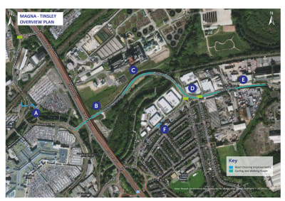
Map of the Connecting Sheffield Magna - Tinsley scheme area
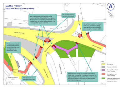
Meadowhall Road Crossing
We plan to relocate the proposed Meadowhall Road crossing point near Alsing Road to go via the existing crossing point between Meadowhall Road and Meadowhall Way.
We are exploring ways to overcome the existing pinchpoint for pedestrians and cyclists on the approach to Alsing Road from Meadowhall Way over the River Don.
Our proposals for the Meadowhall Road crossing
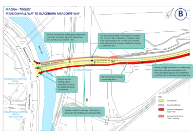
Meadowhall Way to Blackburn Meadows Way
We plan to further separate pedestrians and cyclists along Blackburn Meadows Way to provide more dedicated spaces for cycling, walking and wheeling.
Pedestrians will be able to walk on the pavement on the Meadowhall to Tinsley side of the road, but there will be a shared use section for walking, wheeling and cycling from the crossing under Tinsley viaduct to access the Canal Cycleway link.
Map of the scheme area at Meadowhall Way and Blackburn Meadows Way
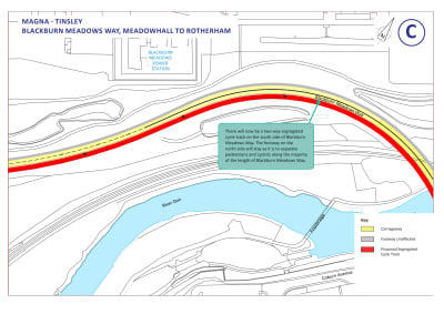
Blackburn Meadows Way, Meadowhall to Rotherham
We will introduce a segregated cycle track on the Tinsley to Meadowhall side of Blackburn Meadows Way.
We propose a shared use section for walking, cycling and wheeling, between Sheffield Road and the Blackburn Meadows Way Meadowhall-bound bus stop.
Map of the scheme area at Blackburn Meadows Way, showing the proposed cycle track
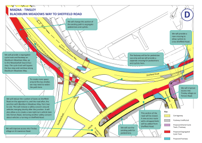
Blackburn Meadows Way to Sheffield Road
We plan to reduce the width of the Blackburn Meadows Way two-way cycle track on the approach to Meadowhall Way from 4m to 3m, so we can keep two lanes for road traffic approaching Meadowhall Way.
We plan to reduce the number of vehicle lanes on Sheffield Road, heading towards Rotherham, from two to one at the junction with Blackburn Meadows Way. This will help to remove a safety concern around vehicles having to quickly merge after the junction.
Map of the scheme area at Blackburn Meadows Way to Sheffield Road
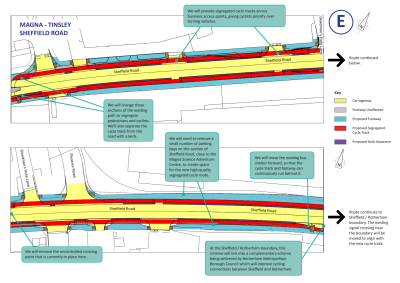
Sheffield Road
We plan to further separate pedestrians and cyclists from vehicles and each other along Sheffield Road to provide more dedicated spaces for cycling, walking and wheeling with one-way cycle tracks to directly connect into the scheme being delivered on Sheffield Road in Rotherham.
We propose continuous pavements and cycle tracks across business access points on Sheffield Road where appropriate to give pedestrians and cyclists priority over turning vehicles.
We propose to Introduce the ability to turn right into Tinsley Village from Sheffield Road to improve access into Tinsley. This will help to remove a safety concern of vehicles u-turning on Sheffield Road.
Map of the scheme at Sheffield Road
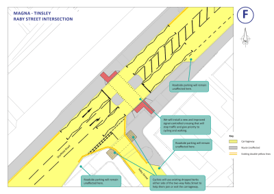
Raby Street intersection
Map of the scheme at the Raby Street intersection
What's next?
In the new year, we will advertise the Traffic Regulation Orders (TROs) required for the scheme. A TRO is a legal order which allows councils to change the way roads are used, such as regulating the speed limit, banning or enabling turns, making a road one-way or changing loading and waiting restrictions – often indicated by parking bays or yellow lines.
Once we have advertised the order, there is a 28-day formal objection period. We must consider all objections before we can make a TRO operational.
We will let you know when the TROs are advertised and how to provide formal feedback.
In the meantime, we’ve included the plans for the TROs below. If you have any questions, comments or concerns, you can let us know by emailing us via connectingsheffield@sheffield.gov.uk
Sheffield Road TRO
Sheffield Road Traffic Regulation Order plan
We’re proposing to extend the existing 24-hour main carriageway clearway to the Rotherham boundary, which will include no stopping on footways to improve traffic flow and continuity for the cycleway.
Ferrars Road TRO
Ferrars Road Traffic Regulation Order plan
Vehicles travelling onto Sheffield Road from Ferrars Road will only be able to turn left – they won’t be able to u-turn or turn right, which will reduce potential collisions from the new right turn from Sheffield Road into Ferrars Road.
Further information about Connecting Sheffield: Magna - Tinsley
You can view the 2021 consultation report for this scheme here. You can also view an Executive Summary of the report here.
Connecting Sheffield: Magna-Tinsley is designed to deliver improvements to walking and cycling infrastructure and to provide better connections to public transport links to make it easier for people to travel around and between Magna, Tinsley and Meadowhall by walking, wheeling, cycling and using public transport.
These changes will increase access to leisure and employment opportunities at Meadowhall and in Rotherham and Sheffield for Tinsley residents.
By providing high-quality walking and cycling routes, these proposals will make walking and cycling for shorter journeys a more attractive and accessible option as well as improving travel choices for people without access to a car.
Key aims are to reduce the reliance on car travel for shorter trips which will keep roads clearer for public transport and people who have to travel by car, and help improve air quality around Magna, Tinsley and Meadowhall.
View pdfs of the maps for Connecting Sheffield: Magna - Tinsley scheme