Home
Neepsend-Kelham-City Centre
Neepsend-Kelham-City Centre
Consultation on Neepsend-Kelham-City Centre closed on 3rd March 2021.
You can now view the consultation report for this scheme here . You can also view a shorter Executive Summary of the report here .
Introduction
Connecting Sheffield: Neepsend-Kelham-City Centre is the latest phase of Connecting Sheffield, a new approach designed to transform travel in Sheffield via cycling, walking and public transport alongside complementary environmental improvements. We are now consulting on our proposals for this scheme and would like to hear your views.
Kelham Island has become an increasingly vibrant and cosmopolitan inner-city residential district and visitor destination, and Neepsend is now following suit. The St Vincent’s Quarter around West Bar and Shalesmoor is also seeing new homes developed across the inner ring road, linking Kelham and Neepsend to the City Centre.
Connecting Sheffield: Neepsend–Kelham–City Centre has been designed to reinforce and accelerate the development of Neepsend and Kelham, helping to improve the environment of these areas and linking them into the heart of the City through new, high-quality cycling and walking infrastructure and improved routes for bus services. This scheme will feature two new improved high-quality walking routes to connect communities in Pitsmoor and Burngreave to employment opportunities in the City Centre and will improve the northern gateway to the City Centre, complementing the proposed Connecting Sheffield: City Centre project.
Click here to see a map showing the full extent of this scheme. More detailed maps of key areas where changes are proposed are provided further down this page.
Neepsend and Kelham
A series of measures will see Kelham and much of Neepsend become an ‘Active Neighbourhood’, with lower traffic volumes making it easier and more attractive to cycle and walk and transforming streets into safer and more pleasant spaces that enable uses such as pavement cafes and events.
To achieve these lower traffic volumes, the B6074 will be diverted so that traffic runs around Kelham and Neepsend rather than through it. The permanent closure of Alma Street and Ball Street to through traffic will also contribute to this aim. Vehicle access will still be maintained for residents, businesses and deliveries.
A minimal amount of on-street parking will be removed as part of this scheme. A controlled parking zone scheme in Kelham and Neepsend is planned, with local residents and businesses due to be consulted on the proposals from Spring 2021 via a separate consultation. Enforcement of existing parking restrictions will also help to reduce the domination of the area by illegally parked cars.
The map below shows how the roads in Neepsend will be redesignated:
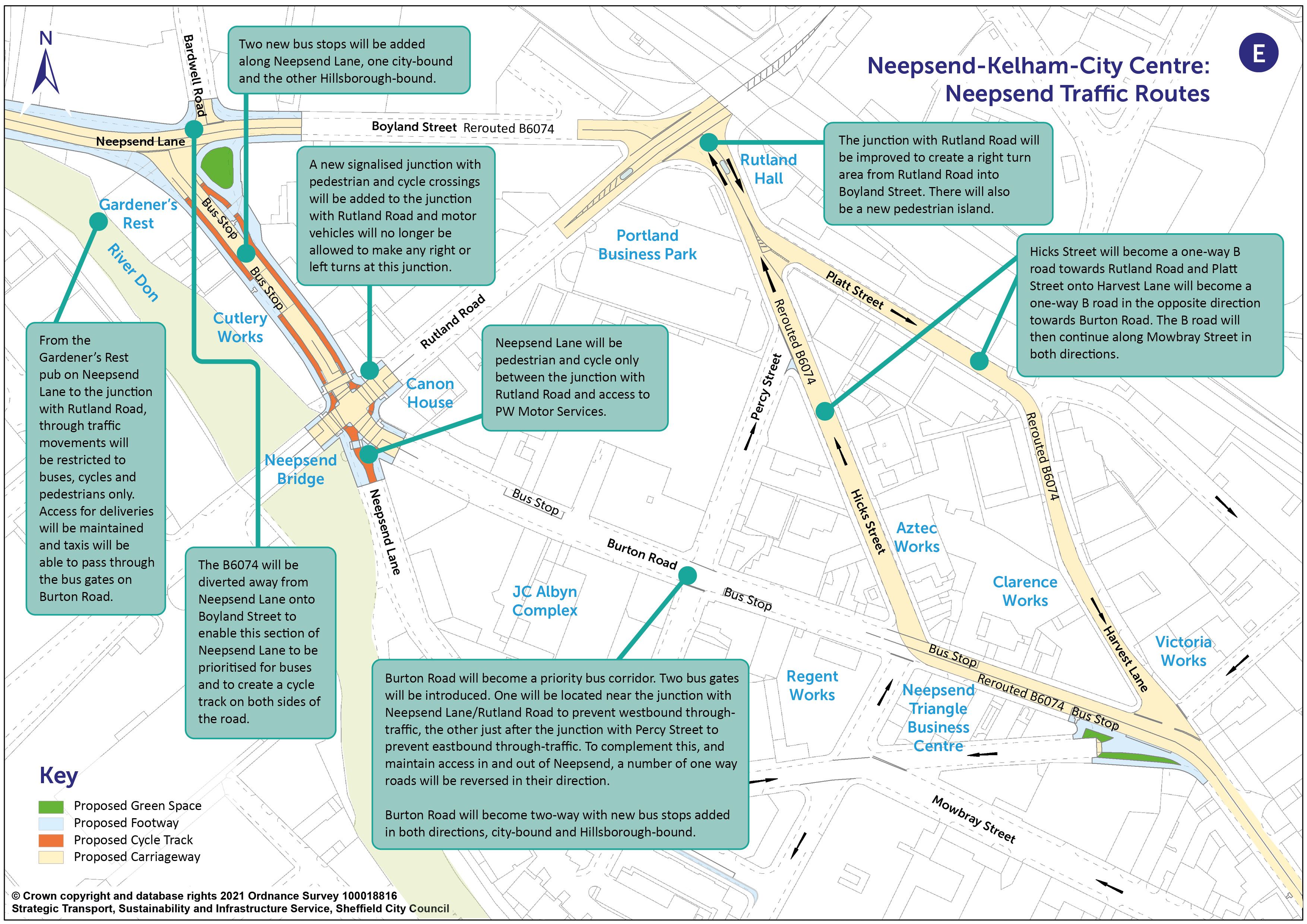
You can view a pdf of the above map and zoom in by clicking here .
As well as reducing traffic levels in the area by removing through traffic, the proposals will give public transport priority which will make journeys by bus faster and more reliable. Improvements to bus stops will be delivered along with additional bus stops for the rerouted Hillsborough bound bus service along Burton Road.
Bus gates, which remove general through traffic in favour of bus access, are to be introduced along Burton Road, one at its junction with Rutland Road and Neepsend Lane to prohibit westbound through traffic, the other where Burton Road meets Percy Street to prohibit eastbound through traffic. Vehicles will still be able to use Burton Road for access to existing premises, however, with Burton Road becoming two-way to enable this.
The proximity of Kelham to the A61 Inner Ring Road, Penistone Road, the A6109 starting at Savile Street, and Sheffield Parkway means that through traffic can be removed from local streets to more suitable routes to create an area where space is predominantly focused on walking and cycling. This will create more of a community feel in the area and provide a meeting place where people can spend time.
Rutland Road will remain in use to carry general through traffic between the A61 Inner Ring Road and Parkwood Springs, Pitsmoor and Parson Cross.
A new cycling and walking route will be created, starting outside the Gardener’s Rest pub on Neepsend Lane in Neepsend. Various routes will be available due to the reduction of traffic in the area. A primary route option would see people walk or cycle along Neepsend Lane from the junction with Rutland Road heading east, along Ball Street over the bridge via Lancaster Street and along Green Lane and Russell Street to the inner ring road and into the City Centre at West Bar.
The improvements for cycling and walking will continue from Green Lane along the Penistone Road service road. This will join up with the existing shared use footway alongside the A61 via a junction hump which is a speed hump covering an entire junction. A new full width road hump with pedestrian crossing point just to the north-east of the Green Lane junction will slow motor vehicles down and provide a crossing point for people over the service road.
The map below shows the measures proposed for Kelham to achieve the 'Active Neighbourhood':
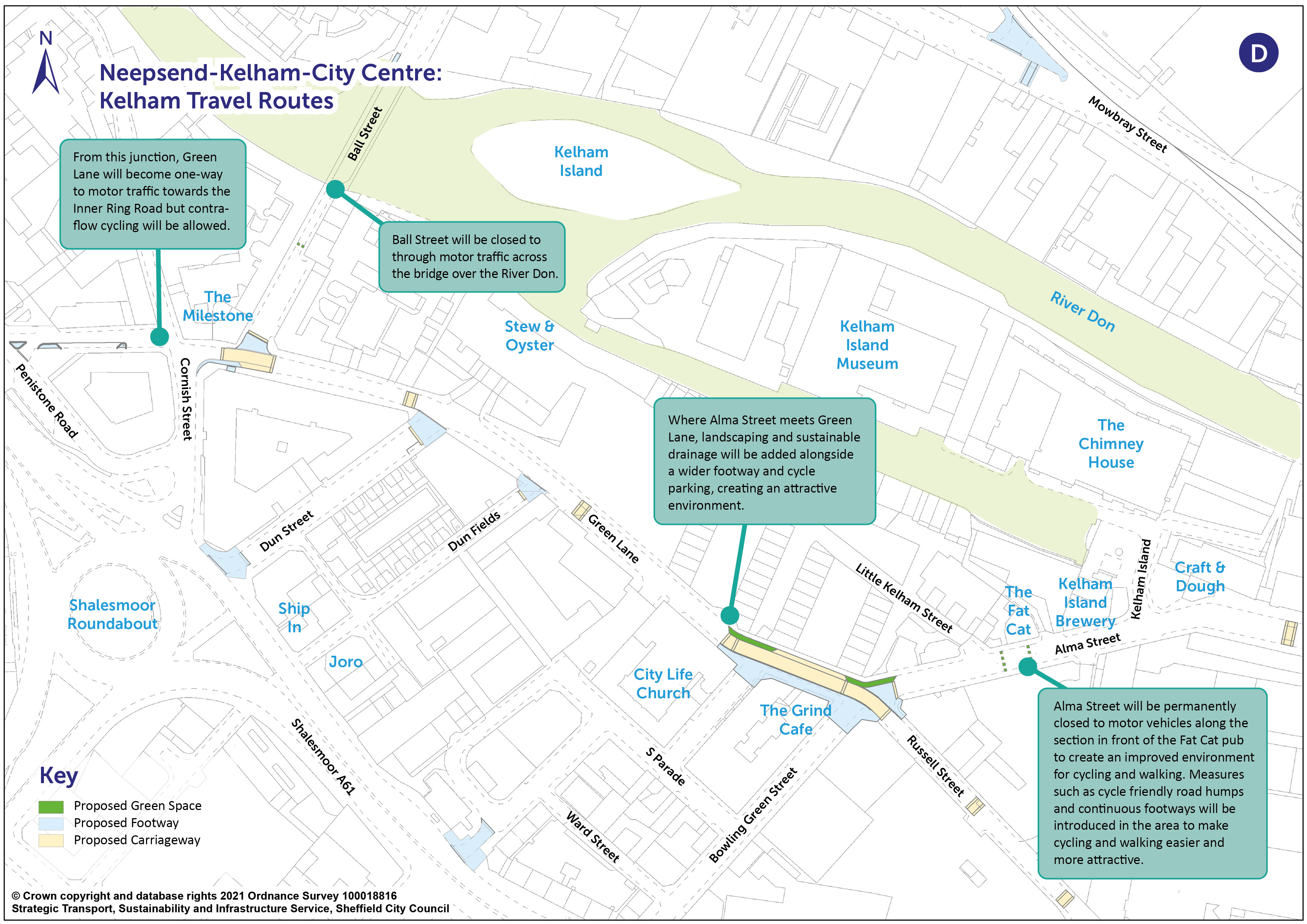
You can view a pdf of the above map and zoom in by clicking here.
The measures above are designed to improve the environment for cycling and walking and to improve bus services through the area. The cycling routes will also connect into the existing Penistone Road cycle route, providing an enhanced connection between Hillsborough, Kelham and Neepsend, the City Centre at West Bar, and onwards to the Lower Don Valley.
Changes to traffic routes
More detailed information on the changes to traffic routes in Neepsend and Kelham can be found here .
West Bar
The improved environment for cycling and walking through the ‘Active Neighbourhood’ in Neepsend and Kelham will continue along Russell Street through a pocket of landscaping. The route will cross the inner ring road, supported by a new controlled cycle crossing alongside the existing pedestrian crossing as shown on the plan below.
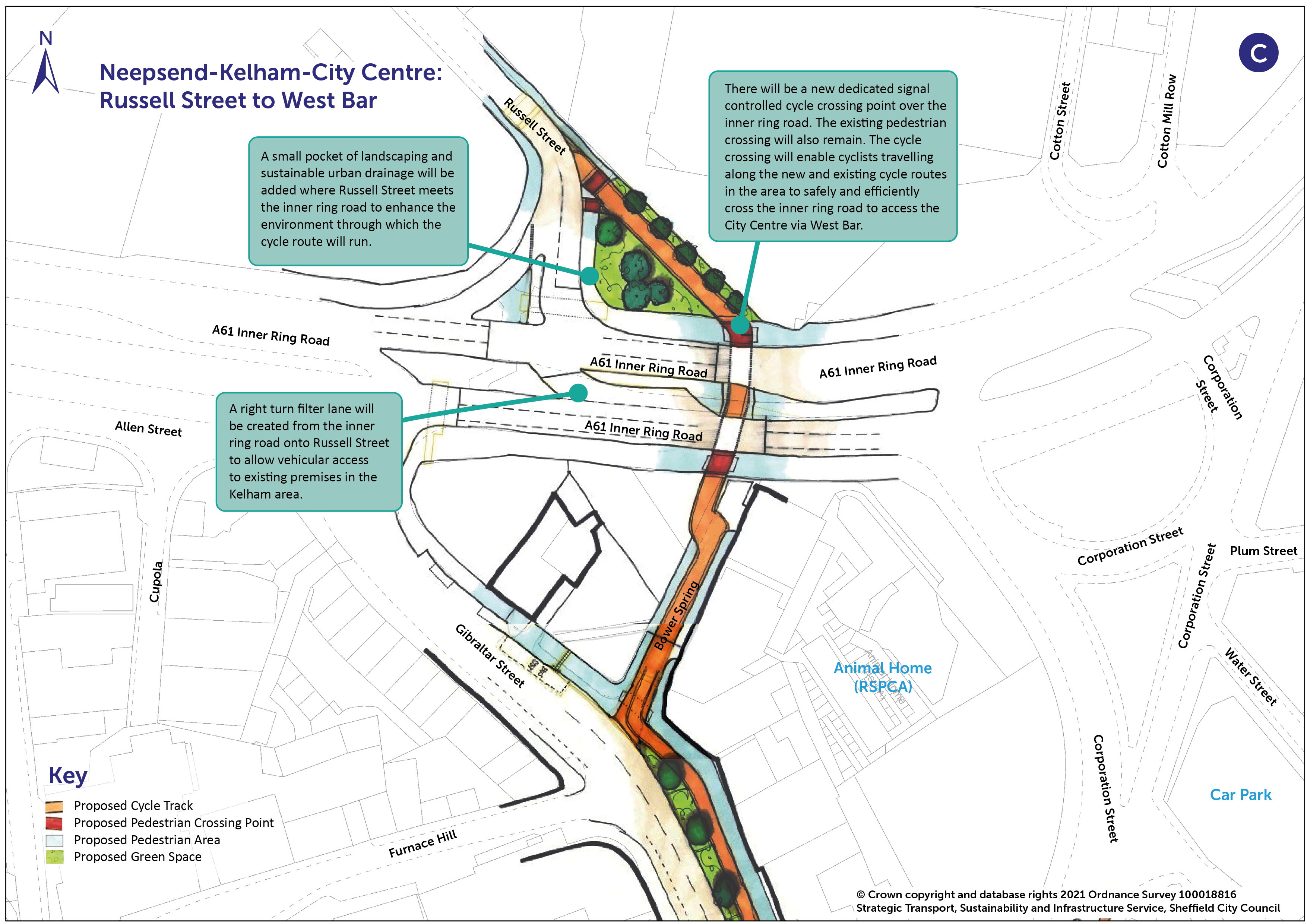
You can view a pdf of the above map and zoom in by clicking here .
Landscaping, planting and new trees will be added along the routes around West Bar to provide an improved environment for walking and cycling. This will be similar to the Grey to Green approach used in other areas of the city centre such as Castlegate and will create new green public spaces, making key streets more attractive. Where possible, sustainable urban drainage will be integrated into the landscaping to support flood mitigation.
New segregated cycle tracks away from the main highway will be introduced where traffic volumes are higher between the A61 Inner Ring Road and West Bar and into the city centre along Tenter Street.
The roundabout at West Bar will be converted to create Sheffield’s first Dutch-style roundabout which will give cycling and walking priority over motor traffic at junction crossings.
A segregated cycle track will run around the roundabout and pedestrian and cycle crossings will be positioned on each arm of the roundabout to make it safer and easier to cross the road. Dutch-style roundabouts are designed to reduce traffic speed much more than normal roundabouts which creates a safer environment for walking and cycling. Cyclists travelling around the roundabout will have priority over general traffic. Signage will be put in place to alert motorists to the changes in priority.
Dutch-style roundabouts are already in use elsewhere in the UK. Click here to view a video produced by Cambridgeshire County Council which illustrates how a Dutch-style roundabout works. The proposals for West Bar roundabout are based on the same principles as the scheme shown in this video and will give priority to walking and cycling. There will, however, be design differences between the roundabout shown on the video and the roundabout proposed at West Bar.
The proposal for West Bar roundabout is illustrated on the plan below:
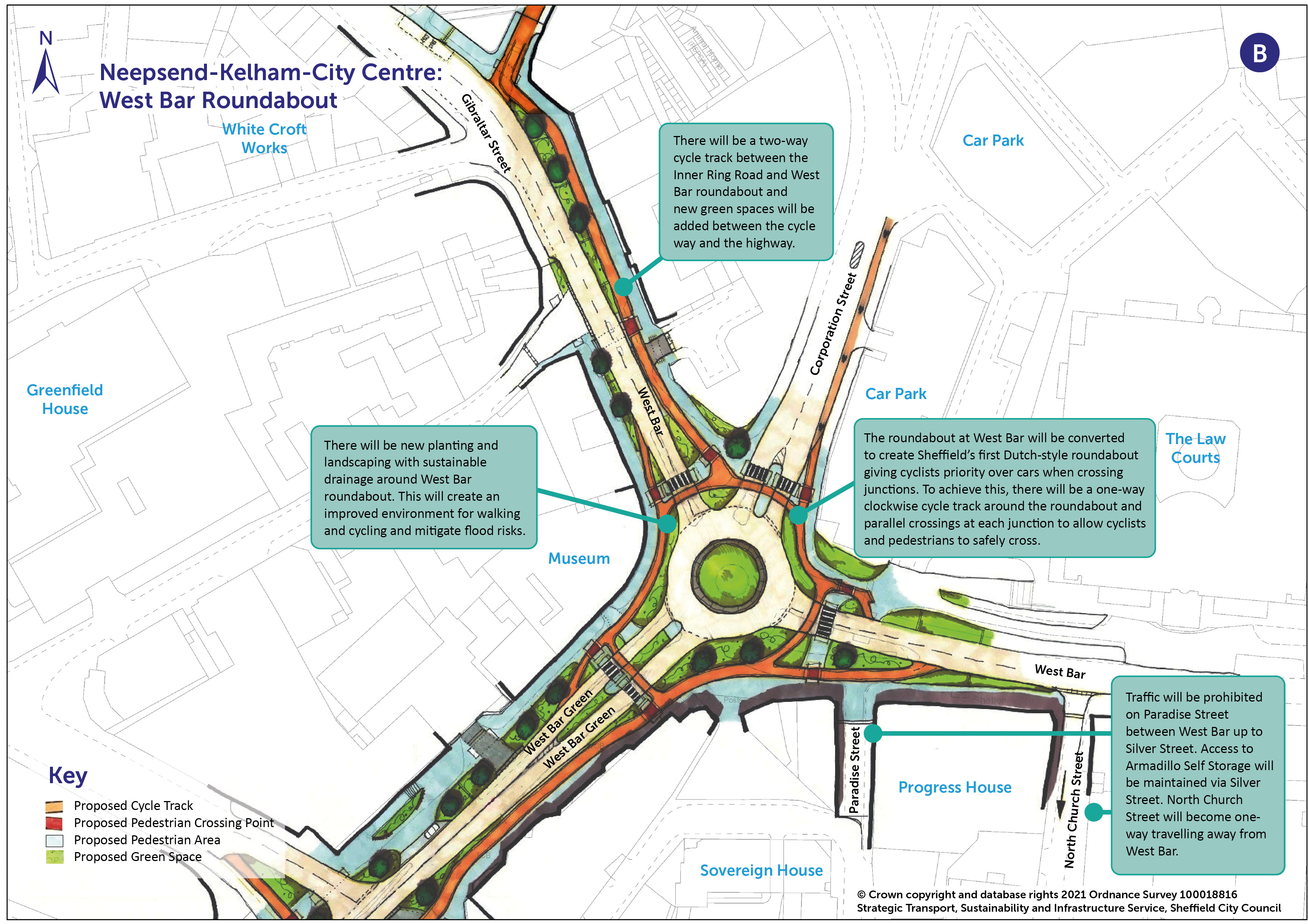
You can view a pdf of the above map and zoom in by clicking here .
The photomontage below provides an indicative visualisation of West Bar roundabout where landscaping measures are proposed alongside significant improvements for cycling and walking. The improvements will provide much improved links between the city centre and Gibraltar Street for people living, working and socialising in these areas. The slider can be moved to show the viewpoint at present compared to the viewpoint after the scheme is delivered.
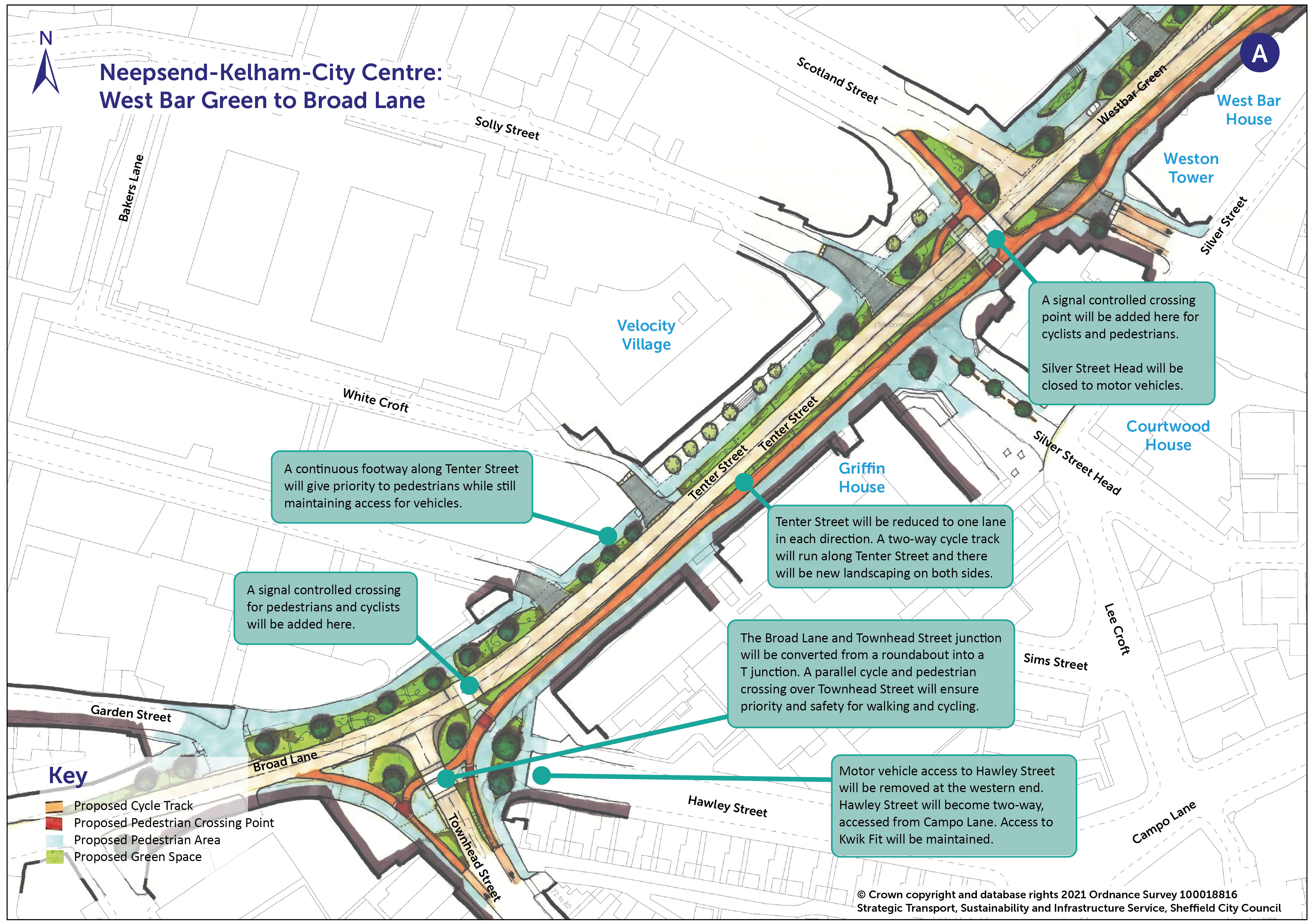
The new segregated cycle track and landscaping will continue from West Bar roundabout along Tenter Street on the side heading into the City Centre. Tenter Street will become one lane in each direction for vehicle traffic. New signal-controlled crossings will be added to facilitate cycling and walking and a * continuous footway ( see the details below for Burngreave and Pitsmoor for an explanation of a continuous footway ) over junctions running off Tenter Street along the side streets towards West Bar roundabout will give priority to pedestrians. With the exception of Silver Street Head, access for vehicles to each side street and on Tenter Street itself will be maintained.
The roundabout currently in place at the junction of Broad Lane will be replaced with a T-junction which will provide a safer and more accessible route for cycling and walking into the city centre. Vehicle access to and from Hawley Street where it meets Townhead Street will be removed, with Hawley Street becoming two-way with access from Campo Lane.
From the new T-junction, the cycle track will travel up Townhead Street to connect into the cycle tracks starting at Leopold Street that have been consulted on under Connecting Sheffield: City Centre .
You can view a pdf of the above map and zoom in by clicking here .
Burngreave and Pitsmoor
Connecting Sheffield: Neepsend-Kelham-City Centre also includes two new high-quality walking routes to connect communities in Pitsmoor and Burngreave with Neepsend, Kelham and the City Centre. The first route runs along Nottingham Street and Rock Street, the second along Burngreave Road and Spital Hill. The routes are shown on the map below:
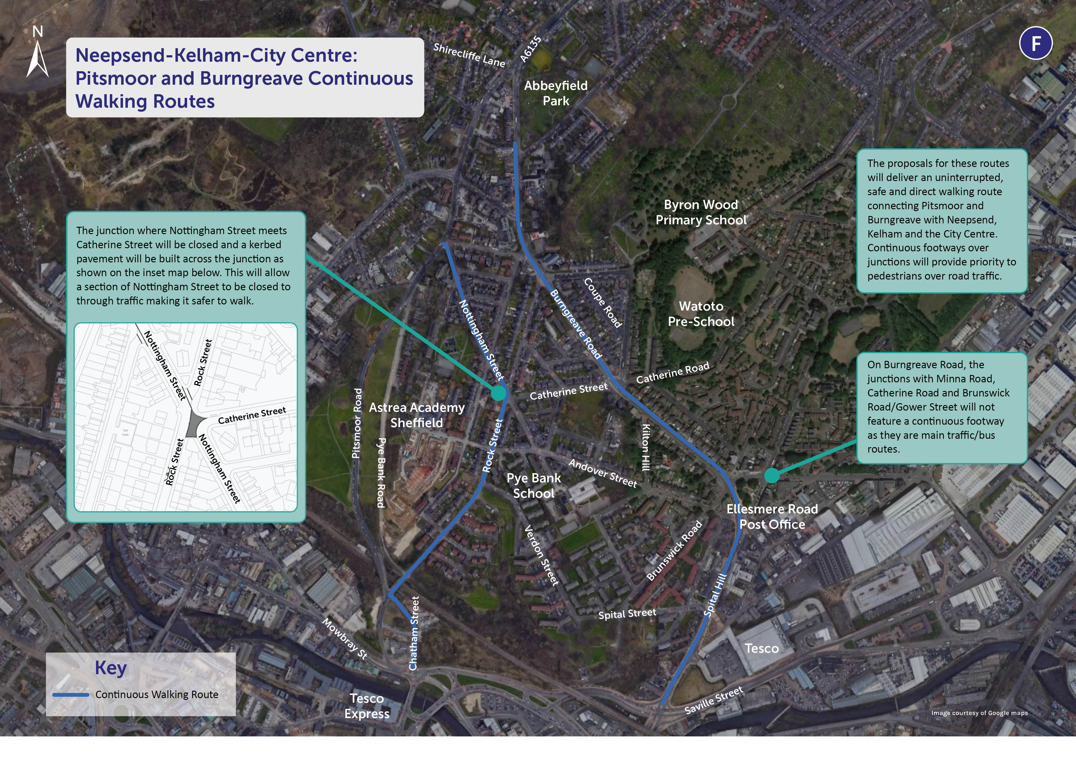
You can view a pdf of the above map and zoom in by clicking here .
Where the northern section of Nottingham Street meets Rock Street, vehicle access will be removed to allow the footpath to run continuously across this previously existing junction. Alternative access to Rock Street and Nottingham Street will be via Andover Street.
Bus stops along Nottingham Street and Rock Street will be upgraded with high kerbs to make it easier to get on and off the bus, and shelters to protect people from the weather while they wait for a bus.
Measures will be implemented at all minor side road junctions open to traffic along these routes to give priority for walking. The pinch point build outs currently in place on Rock Street will be replaced with full width road humps to better manage traffic flow.
A new pedestrian island will be created in the middle of Burngreave Road just above the junction with Abbeyfield Road, making it easier to cross the road to and from Abbeyfield Park and the children’s playground. The existing pedestrian island in the middle of Burngreave Road just to the south of Abbeyfield Road will be improved.
A number of * continuous footways will be introduced along the walking routes. Continuous footways are based on an approach applied in The Netherlands which gives priority to pedestrians at the approach to side road junctions rather than to motor vehicles as is currently the case.
Footpaths will run continuously across junctions at the same level as the pavement, and road traffic will have to travel over the raised footway via ramps to exit the junction. This will slow traffic down to enhance safety.
The visualisation below illustrates how continuous footways work:
The continuous walking routes in Pitsmoor and Burngreave will be the most ambitious walking routes in the city and will dramatically improve local walking connections and encourage walking in place of car trips for short journeys.
----------------------
To help us to monitor the success of this project we may need to occasionally survey traffic in the area using cameras mounted on lamp posts. We need to do this so that we can understand how traffic has been affected by the scheme. For example on certain roads we may wish to understand whether traffic has reduced or increased as a result of the scheme.
If you have any queries, concerns or complaints about the way Sheffield City Council processes your personal data, including the way we handle information requests, you can contact our Customer Services or the Data Protection Officer.
If you are not satisfied with our response or believe we are not processing your personal data in accordance with the law you have the right to contact the Information Commissioner’s Office.
This engagement phase has finished

...