Home
Crookes and Walkley Active Neighbourhood: Latest Updates
Crookes and Walkley Active Neighbourhood: Latest Updates
September 2023
Crookes and Walkley Active Travel Neighbourhood to be made permanent
On Wednesday 20 September, Sheffield City Council’s Transport, Regeneration and Climate Policy Committee considered proposals to introduce the active travel neighbourhoods in Crookes and Walkley on a permanent basis.
Reports to the Committee outlined the schemes’ delivery, their impact and public consultation results, and the Committee approved the proposals to implement the schemes permanently.
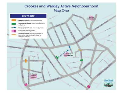
The Crookes scheme includes:
- Changes to vehicle access on parts of Hands Road and Newent Lane
- A School Street allowing access for pedestrians and cyclists only – except for authorised vehicles and permit holders – at Westways Primary School, which affects Mona Avenue and Mona Road during school drop off and pick up times
- No waiting at any time on parts of Cobden Place, Cobden View Road, Hands Road, Leamington Street, Matlock Road, Melbourn Road, Mona Avenue, Pickmere Road, Romsdal Road, Sackville Road, Slinn Street, Townend Street and Warwick Terrace
- No waiting Monday to Friday 9am to 5pm on part of Western Road
- Amendments to permit holder parking places on Crookesmoor Road
- Pedestrian crossings at Crookesmoor Road and Crookes (near School Road)
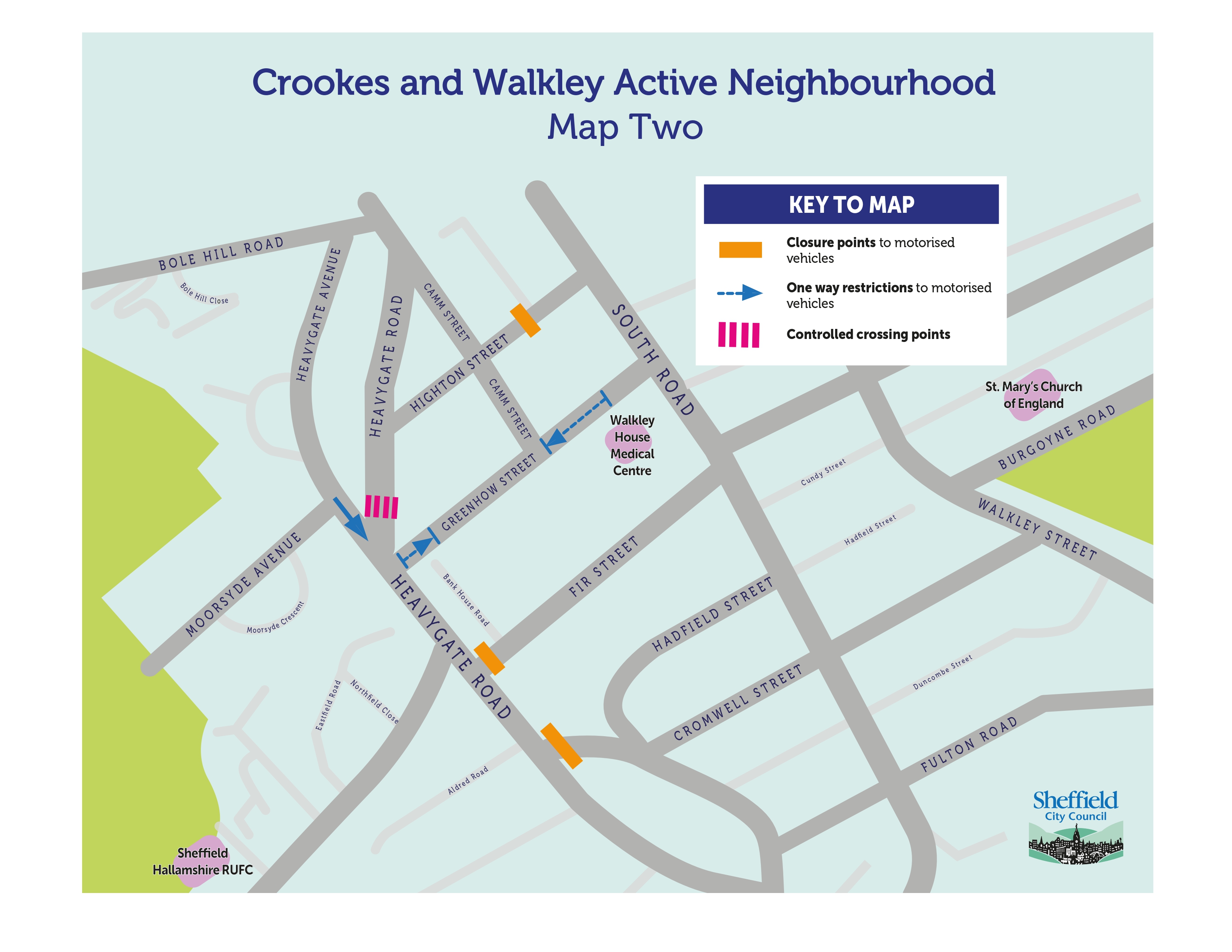
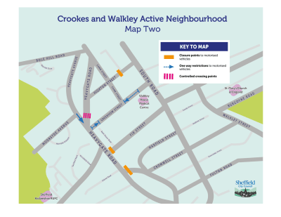
The Walkley scheme includes:
- Changes to vehicle access on parts of Fir Street, Highton Street and Matlock Road
- One way on parts of Greenhow Street and Heavygate Avenue
- No waiting at any time on Camm Street, Greenhow Street, Heavygate Avenue, Highton Street, Matlock Road
- Pedestrian crossings at Heavygate Road
You can view the report that the Committee considered online, and there is more information in our news release.
We’ll publish more information on the permanent schemes here and our programme of works soon.
Traffic monitoring data document
In order to monitor and evaluate the success of the active neighbourhood, we’ve conducted traffic monitoring surveys at a number of junctions around the route and the surrounding areas. These surveys capture the movements of motorised vehicles, cyclists and pedestrians between each arm of the junction.
We have also worked with The Floow, specialists in black-box telematics data, to better understand traffic flows around the active neighbourhood. This data includes journey times, estimated traffic flows, traffic speeds and concentrations of through traffic.
Document 1: Crookes and Walkley: Overview vehicle count
Document 2: Crookes and Walkley: Overview pedestrian and cyclist count
Document 3: Crookes and Walkley: Junction vehicle counts: School Road, Crookes Road and Conduit Road
Document 4: Crookes and Walkley: Junction vehicle counts: Heavygate Road and Northfield Road
Document 6: Crookes and Walkley: Overview: Pedestrian crossings
Document 7: Crookes and Walkley: Traffic movement flow data
Document 8: Crookes and Walkley: Journey times: Crookes Road and Crookesmoor Road
Document 9: Crookes and Walkley: Journey times: Northumberland Road, Springvale Road and School Road
If you would like to see the raw traffic monitoring data from which we produced the Traffic Monitoring Data Documents shared on this web page, please get in touch with us by email (info@connecting-sheffield.co.uk) or phone (0808 196 5105).
Face to face perception survey report
In order to monitor and evaluate the success of the Active neighbourhood, we’ve conducted perception surveys of residents, active travel route users and local businesses.
You can view the report summarising the methodology and results of this survey by clicking here.
Online perceptions surveys
The face to face perception surveys were also adapted and put online through the Connecting Sheffield website for anyone to provide feedback.
You can view the report summarising the results of this survey by clicking here.
Background
The Crookes and Walkley Active Neighbourhood aims to create a safer, cleaner and more pleasant environment for residents and local businesses to enjoy and a more attractive area for walking, cycling and spending time outdoors.
In summer 2021, we asked what you thought an Active Neighbourhood in your area could look like. Through our online survey and heatmap, you told us that you would like:
- Improved crossing points
- Safer areas for children to play
- Dedicated spaces for cycling
- A reduction in traffic
- Improved footpaths for walking
- Changes to parking
66% of respondents told us they felt positively about the proposal to create an Active Neighbourhood. During that consultation, some people raised concerns about access to homes and businesses being restricted. There were also concerns about parking potentially becoming more difficult. You can view the 2021 consultation and final report here.
The feedback we received during that consultation helped to inform the design of the Active Neighbourhood.
Creating the Active Neighbourhood
In April 2022, we put measures in place to create the Active Neighbourhood via an ‘Experimental Traffic Regulation Order’ (ETRO). The ETRO allowed us to put in place the planned road closures, crossings, and one-way systems as a trial on a non-permanent basis. As part of this trial, we asked local people to provide their feedback during a six-month period of consultation so we could understand how the Active Neighbourhood was working and make any changes where necessary.
Due to unforeseen delays in putting all of the planned Active Neighbourhood measures in place, we extended the consultation period to give residents the chance to experience how the Active Neighbourhood worked in its entirety including through the winter months.
The plans originally included:
- 13 proposed road-point closures
- two on Springvale Road at the junctions with Cobden View Road and Western Road;
- two on Matlock Road at its junctions with Heavygate Road;
- two on Newent Lane;
- two on Slinn Street;
- one at the junction of Pickmere Road and Sackville Road and another at the junction of Sackville Road and Romsdal Road;
- one at the junction of Leamington Street and Hands Road;
- one on Fir Street;
- and one on Highton Street.
- Five one-way restrictions
- two at either end of Greenhow Street;
- one on Heavygate Avenue;
- one on Springvale Road;
- and one on Mona Avenue.
- Three controlled pedestrian crossings
- one on Crookes;
- one on Heavygate Road;
- and one on Crookesmoor Road.
- One School Street.
Changes to the Active Neighbourhood
We listened carefully to feedback from local people throughout the trial period and made some changes to the Active Neighbourhood as a result.
- As the closure at the junction of Sackville Road and Pickmere Road reduced through-traffic sufficiently, we removed the closure at the junction of Sackville Road and Romsdal Road.
- To provide an alternative route during snowy periods and to retain access to the church and pub, we removed the closures on Slinn Street.
- To allow easier refuse collection, we repositioned the closure on Newent Lane.
- To maintain an access route between Crookes and Walkley we removed the closure at the eastern junction of Matlock Road and Heavygate Road
- To maintain sufficient space for vehicles to manoeuvre, we removed the diagonal closures on Springvale Road at the junctions with Cobden View Road and Western Road.
- As the double yellow lines on the corners of Western Road and Cobden View Road were no longer necessary following the removal of the diagonal closures, we restored the double yellow lines to their original lengths.
- To reduce the impact of displaced traffic using Melbourn Road, we removed the one-way restriction on Springvale Road
The maps below show the scheme as it currently stands.

To view this map as a pdf, click here.
 To view this map as a pdf, click here.
Responding to Feedback
Thank you to everyone who has shared their feedback on the Active Neighbourhood trial. If you’ve sent an email, written a letter or spoken to a member of our team on the phone, please be assured that we’ve logged your feedback and it will be taken into consideration by our project team.
In June and July 2022, we held three community drop-in sessions in Crookes and one drop-in session in Walkley where we met with residents to discuss the scheme and answer questions. We’ll also take into account the feedback from these events.
Next Steps
The period for comments on the Experimental Traffic Regulation Order (ETRO) for the Crookes and Walkley Active Neighbourhood ended in March 2023. An ETRO allows measures to stay in place for up to 18 months. During the remainder of the ETRO period, the Active Neighbourhood will remain in place while decisions are made around which elements of the trial should stay, be removed or changed.
Survey
During May 2023, we’ll be asking residents and businesses for your views on how you think the Active Neighbourhood trial has changed the area.
We want to know whether you think it’s achieved the aims of making it a safer, cleaner and more pleasant environment for people and businesses to enjoy and a more attractive area for walking, cycling and spending time outdoors. As well as the face-to-face survey, we have added the survey questions to this web page for you to answer online too.
The survey closed on Wednesday 28 June at 9am. Thank you to everybody who shared their feedback.
Traffic Monitoring Data
In November 2021, before the Active Neighbourhood trial began, we conducted traffic monitoring surveys at a number of junctions across Crookes and Walkley to obtain baseline data. These surveys capture the movements of motorised vehicles, cyclists and pedestrians.
We surveyed junctions where we anticipated a potential change in travel because of the scheme, including areas of potential traffic where traffic may have moved to another route as a result of the Active Neighbourhood. We also surveyed how the controlled pedestrian crossings we implemented as part of the scheme were used.
We repeated this exercise in September 2022 and then again in April 2023. We are currently analysing the data to understand how traffic flows have changed since the Active Neighbourhood was created and will share our findings on this web page. We expect this to be available in summer 2023.
Decision Making
We expect that a final decision on the scheme will be made in September 2023 by Sheffield City Council’s Transport, Regeneration and Climate Policy Committee. The decision will be informed by the results of traffic monitoring surveys, feedback received during the trial period and the results of the surveys we’ll conduct in May. We’ll communicate the decision the Committee makes via a letter to the local community and on the Connecting Sheffield website.
Contact Details
You can get in touch with the Connecting Sheffield team using the following channels:
Email: info@connecting-sheffield.co.uk
Freephone: 0808 196 5105
Post: Freepost Connecting SHF
To access and complete the online survey asking about your experience of the Crookes & Walkley Active Neighbourhood, please click here. The survey will close on Wednesday 21st June at 9am.
If you or someone you know is unable to access information online, please get in touch with us using the contact details above. We can arrange a different way to provide information and record feedback so that you or they can get involved.
Crookes and Walkley Active Neighbourhood maps
Traffic monitoring data documents


Face to face perception survey report
Online perception survey report