Home
Nether Edge-City Centre
Nether Edge-City Centre
Update: 29 April 2024 - Trial hole excavation works to begin
We are starting trial hole excavation works in a number of locations to help us finalise the design for the Connecting Sheffield: Nether Edge – city centre project.
Works start on Wednesday 1 May, and will help us to confirm where different services are located underground.
We will use a very large vacuum excavator, which will create some noise, but we aim to complete each trial hole and reinstate the paving within a day. But there may be some instances where this may take an extra day.
Due to the location of some of the holes we need to excavate, we will need to do some of the works overnight. We will aim to complete these as quickly as possible and will aim to minimise disruption as far as possible.
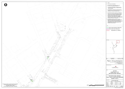
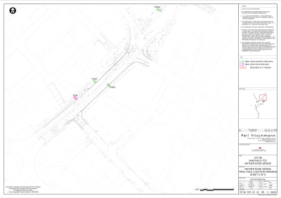
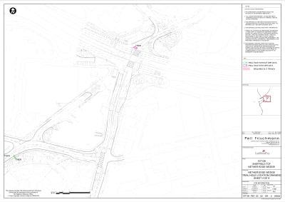
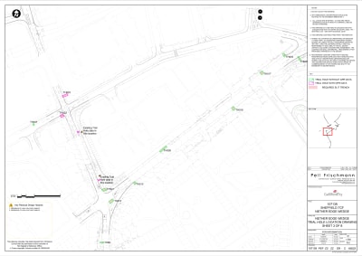
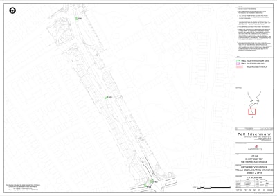
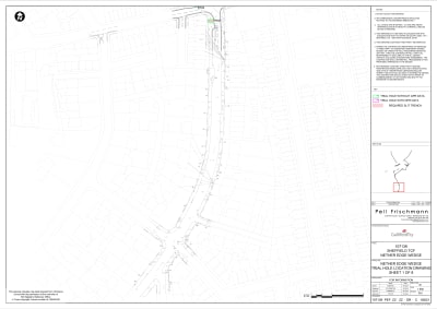
The table below shows when and where we will be doing the trial hole work, and whether the work will be at night.
| Trial hole | Work duration | Start | Finish | Working hours | Location |
|---|---|---|---|---|---|
| Trial hole 3 | 1 day | Wednesday 1 May | Wednesday 1 May | 9.30am to 3.30pm | Wostenholm Road |
| Trial hole 4 | 1 day | Thursday 2 May | Thursday 2 May | 9.30am to 3.30pm | Sharrow Lane |
| Trial hole 5 | 1 day | Friday 3 May | Friday 3 May | 9.30am to 3.30pm | Washington Road |
| Trial hole 21 | 1 day | Sunday 5 May | Sunday 5 May | 8am to 5pm | Summerfield Street |
| Trial hole 6 | 1 day | Tuesday 7 May | Tuesday 7 May | 9.30am to 3.30pm | Washington Road |
| Trial hole 8 | 1 day | Wednesday 8 May | Wednesday 8 May | 9.30am to 3.30pm | Washington Road |
| Trial hole 11 | 1 day | Thursday 9 May | Thursday 9 May | 9.30am to 3.30pm | Cemetery Road |
| Trial hole 13 | 1 day | Friday 10 May | Friday 10 May | 9.30am to 3.30pm | Cemetery Road |
| Trial hole 23 | 1 day | Sunday 12 May | Sunday 12 May | 8am to 5pm | Summerfield Street |
| Trial hole 22 | 1 day | Monday 13 May | Monday 13 May | 9.30am to 3.30pm | Napier Street |
| Trial Hole 37 (shown as 37B on plan) | 1 day | Tuesday 14 May | Tuesday 14 May | 7.30am to 5pm | Napier Street |
| Trial Hole 36 | 1 day | Wednesday 15 May | Wednesday 15 May | 7.30am to 5pm | Washington Road |
| Trial Hole 38 (shown as 37A on plan) | 1 day | Thursday 16 May | Thursday 16 May | 9.30am to 3.30pm | Cemetery Road |
| Trial Hole 16 | 1 day | Friday 17 May | Friday 17 May | 9.30am to 3.30pm | Cemetery Road |
| Trial Hole 20 | 1 day | Sunday 19 May | Sunday 19 May | 8am to 5pm | Cemetery Road |
| Trial Hole 17 | 1 day | Monday 20 May | Monday 20 May | 7.30am to 5pm | Cemetery Road |
| Trial Hole 19 | 1 day | Tuesday 21 May | Tuesday 21 May | 7.30am to 5pm | Cemetery Road |
| Trial Hole 39 | 1 day | Wednesday 22 May | Wednesday 22 May | Overnight - 8pm to 5am | Moore Street |
| Trial Hole 33 | 1 day | Thursday 23 May | Thursday 23 May | Overnight - 8pm to 5am | Moore Street |
| Trial Hole 32 | 1 day | Tuesday 28 May | Tuesday 28 May | Overnight - 8pm to 5am | Moore Street |
| Trial Hole 34 | 1 day | Wednesday 29 May | Wednesday 29 May | Overnight - 8pm to 5am | Charter Row |
| Trial hole 35 | 1 day | Thursday 30 May | Thursday 30 May | Overnight - 8pm to 5am | Trafalgar Street |
The pdf plans below also show where the different trial holes are located.
If you have any questions about the trial hole works, you can email us via transport@sheffield.gov.uk
We'll update you on the wider project proposals in the coming months, when we've finalised the designs.
----------
Consultation on Nether Edge-City Centre ended on 8 April 2021.
You can now view the consultation report for this scheme here . You can also view a shorter Executive Summary of the report here .
Introduction
Connecting Sheffield: Nether Edge – City Centre is the latest cycling and walking infrastructure scheme under Connecting Sheffield – a new approach designed to transform travel in Sheffield via cycling, walking and public transport alongside complementary environmental improvements. We are now consulting on our proposals for this scheme and would like to hear your views.
The proposals have been designed to deliver new cycling and walking routes connecting the city centre to Nether Edge, and via a spur through Broomhall, to the West End and the University of Sheffield and hospitals. These key areas are situated within just a couple of miles of the City Centre but lack high-quality cycling and walking infrastructure, discouraging many from cycling or walking between these locations.
Connecting Sheffield: Nether Edge – City Centre is designed to change this. By providing high quality, safer and easy-to-use cycling and walking routes, the proposals will make it easier for people to walk and cycle between these areas for short journeys, helping to reduce congestion on the roads, improve air quality within the area and support the creation of a greener, cleaner city. The scheme will also link into the city’s wider cycling network, including the planned Connecting Sheffield: City Centre proposals. Although the proposals for this scheme start at Priory Place rather than the centre of Nether Edge, the intention is to extend further into Nether Edge in a future phase, as and when funding becomes available.
Click here to see a map showing the full extent of the cycling and walking route being proposed through this scheme. More detailed maps of key areas where changes are proposed are provided further down this page.
New and improved walking and cycling routes
The main feature of Connecting Sheffield: Nether Edge – City Centre is the delivery of a direct, largely segregated cycle route to enable people to travel more safely and easily between Nether Edge and the City Centre.
The proposed cycle route will run from Wostenholm Road in Nether Edge right into the heart of the City Centre, where it will connect, via the existing cycle network, into the Connecting Sheffield: City Centre proposals. It will also, in a future phase, include a spur up Hanover Street through Broomhall, connecting into the University of Sheffield, the Children’s Hospital and Sheffield Teaching Hospitals.
Building this new high-quality cycle route would require a number of trees and other planting to be removed and replaced. However, the proposed designs keep any loss to an absolute minimum whilst maintaining the most effective outcome for the cycle route. Any trees lost would be replaced with specimens of a similar or higher standard in line with the Sheffield City Council Trees and Woodlands Strategy 2018-2033 and with advice and input from local residents, interest groups and businesses. Where possible, planting would take place in advance of work starting. Once the project is complete, there would be a net increase in the number and quality of trees and other planting in the area.
The route starts at the junction where Priory Place meets Wostenholm Road. Between that junction and Wostenholm Road shops, the footpath would be widened to provide ample space for both cycling and walking. From the Wostenholm Road shops onwards, a segregated cycling track would be introduced that would run down Washington Road, along Cemetery Road and into the City Centre.
To accommodate the cycle track, the traffic lights at the junction of Washington Road and Wostenholm Road with Sharrow Lane would be altered to provide increased priority for cyclists to cross more safely. Some parking spaces would also be removed on Wostenholm Road to provide the space for this infrastructure to be delivered.
The below map shows the proposed changes at the junction of Washington Road and Wostenholm Road with Sharrow Lane.
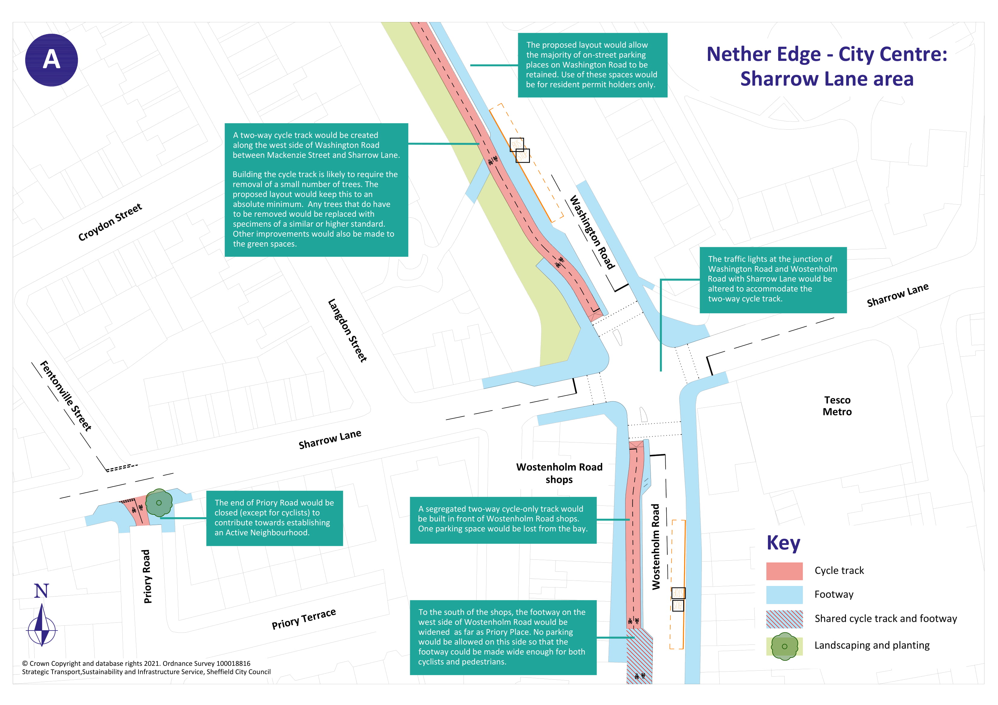
You can view a pdf of the above map and zoom in by clicking here .
As part of the proposals, some road closures would be introduced at the end of Priory Road and Mackenzie Street to deter through traffic and support the creation of 'Active Neighbourhoods' which provide a safer and more pleasant environment for cycling and walking. In these locations, cyclists would be able to travel through the road closure points and a new crossing would be introduced at the junction of Washington Road and Mackenzie Street, to allow safer crossing for cyclists to connect to the cycle track along Cemetery Road.
The below visualisation shows what the new proposed segregated cycle track and walking route along Washington Road will look like.
New landscaping and planting will also be introduced along the length of Washington Road to enhance the environment, which can be seen on the below map.

You can view a pdf of the above map and zoom in by clicking here .
At the junction where Washington Road meets Summerfield Street, cyclists would have the option of turning right onto a one-way track heading eastbound down Cemetery Road or heading straight onto Summerfield Street.
To reduce congestion and create a safer environment for on-street cycling along Napier Street, drivers will no longer be able to turn onto Summerfield Street from Napier Street, or cross from one side of Napier onto the other. Traffic lights and controlled pedestrian crossings will be installed at this junction so that cyclists can pass through safely.
The proposals for these two junctions can be seen on the below map.

You can view a pdf of the above map and zoom in by clicking here .
In addition to this, at the other end of Napier Street, the left turn from Cemetery Road onto Napier Street (traffic will still be able to turn right from Cemetery Road into Napier Street) and the right turn exit lane onto Napier Street from the Waitrose car park will be removed, with a new exit from Waitrose introduced onto St Mary’s Gate. These changes will allow Napier Street to become a low traffic route for cycling and walking. Access to the Waitrose car park, Nuffield Health and other businesses and residential premises on Napier Street would be maintained via Summerfield Street.
Along the section of Cemetery Road from Napier Street to the junction with Washington Road, all on street parking would be removed, however we are exploring options to create some new parking in the vicinity. This will make space available for a one-way cycle track on each side of the road, alongside improved walking routes. Additional parking spaces would be made available elsewhere in the local area. These cycling and walking routes would be continuous and a new crossing would be introduced to provide safer crossing to lower Cemetery Road for pedestrians and cyclists, as seen on the below map.

You can view a pdf of the above map and zoom in by clicking here .
People wanting to travel to the University of Sheffield and hospitals area on foot or by cycle will be able to cross Ecclesall Road via a new crossing. Pedestrians and cyclists will be able to travel along Harrow Street from Napier Street to meet the crossing, which will allow cyclists to cross the road without having to stop in the central reservation.
From Ecclesall Road, the cycling and walking route will continue up Hanover Street and Upper Hanover Street to link with existing cycle tracks at Broomspring Lane.
The proposal for this junction is illustrated on the plan below.

You can view a pdf of the above map and zoom in by clicking here .
Easier access across St Mary’s Gate
Under these proposals, the junction of St Mary’s Gate and London Road would be transformed to provide a more convenient, safer and direct route for cycling and walking into the city centre.
The current subway would be removed and replaced by controlled surface level crossings for both pedestrians and cyclists. These crossings would give priority to cyclists, allowing them to cross the entire junction without having to stop.
Cyclists approaching St Mary’s Gate from Cemetery Road would be able to do so via a new two-way cycle track which will link into the new crossing. New cycle stands will also be introduced on the lower end of Cemetery Road, alongside new trees and planting. The photomontage below provides an indicative visualisation of lower Cemetery Road where landscaping measures are proposed alongside significant improvements for cycling and walking.
A two-way cycle track from Clarence Lane, the Waitrose car park and existing cycle routes to the north, and a new section of one-way cycle track on London Road, would also link into the new crossing.
To create a safer environment for cyclists heading on to South Lane across the inner ring road, the left turn slip road from St Mary’s Gate would be removed and vehicles would instead be able to turn left into South Lane at the traffic lights. To create a low-traffic route between Moore Street and South Lane, Young Street would become a no through road for vehicles. When crossing Young Street, cyclists would have priority over motor vehicles using the road for access.
The below map shows the measures proposed at St Mary’s Gate.

You can view a pdf of the above map and zoom in by clicking here .
Improved City Centre travel
Once across the inner ring road, a series of measures would be introduced to connect into the city centre via Moore Street and Charter Row.
From Young Street segregated tracks would be built along Moore Street and Charter Row to connect into the tracks built as part of the Charter Square redevelopment and proposed as part of the Connecting Sheffield: City Centre proposals. On the northwest side, the track would be one-way (with short sections of two-way track to connect into the junction at Fitzwilliam Gate), while on the opposite side the track would be two-way. A lane of traffic between Fitzwilliam and Young Street would need to be removed.
The proposals for Young Street and Moore Street are illustrated on the below plan.

You can view a pdf of the above map and zoom in by clicking here .
At the junction of Trafalgar Street, priority would be given to crossing cyclists to allow a seamless connection into the Connecting Sheffield: City Centre route at Moorhead.
To provide a smoother and easier journey for cycling and walking, the cycleway/footway surface would be raised up to the existing footway level across the entrances to both Atkinsons car park access and the Sainsbury’s service yard via a raised hump. This still allows vehicles to enter and exit but emphasises that pedestrians and cyclists have priority.
A controlled parallel cycle and pedestrian crossing would be introduced where Fitzwilliam Gate meets Moore Street. This would only allow buses, taxis and cycles to turn on to Fitzwilliam Gate, however access to premises in the area for general traffic would be maintained via Young Street or South Lane.
To give buses priority over other vehicles on Charter Row, traffic lights would be installed at the end of the outbound bus lane on Moore Street near the rear of Atkinsons.
The plans for Charter Row can be seen on the below plan.
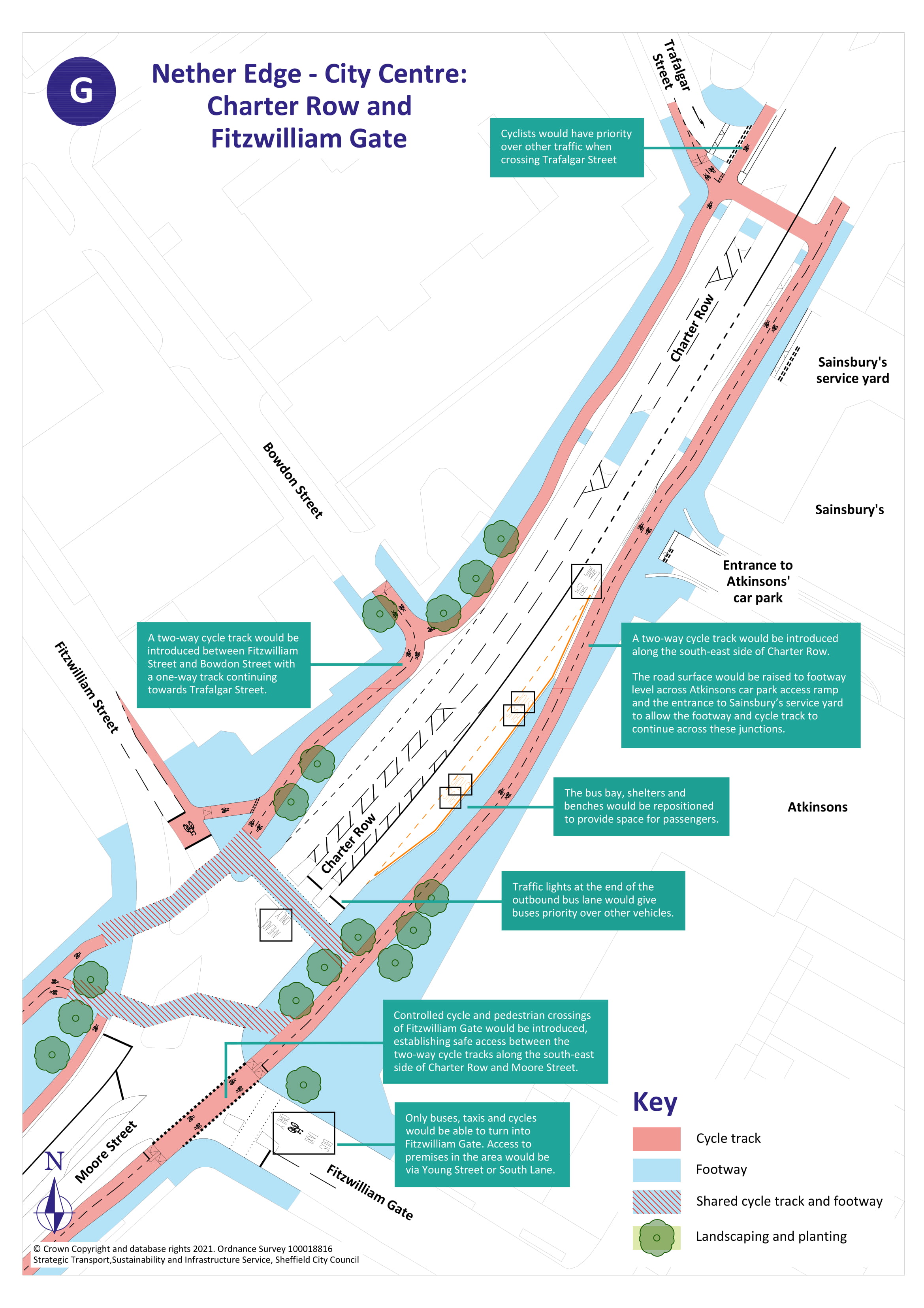
You can view a pdf of the above map and zoom in by clicking here .
A safer, greener, less polluted environment
A key aim of this scheme is to create a greener and less polluted environment along the entire route of the proposals.
Several areas have been identified for new planting and greenery, including along Washington Road, on Cemetery Road and at St Mary’s Gate. Sheffield City Council intends to work with people living in these areas to examine the types of green spaces that residents and businesses would like to see introduced, and to explore possible locations for public realm improvements.
As part of this scheme, changes are also proposed around Pomona Street to support the potential future creation of a ‘school street’ in front of Porter Croft Primary School. The current road closure on Pomona Street would be relocated further towards Porter Croft Primary school, to reduce congestion around the school and allow access to offices at the far end of Pomona Street via Pear Street. Planters and bollards would be used to prevent parking at the approach to the closure, while allowing cyclists and pedestrians to pass through.
A ‘school street’ removes vehicles from an area at school drop off and pick-up times to make it safer for school children and parents to walk and cycle to school during this busy time and removes severe congestion on these roads, reducing vehicle emissions and disturbance for local residents in the immediate vicinity of the school. The proposed implementation of a ‘school street’ would not be part of this consultation but would instead be consulted on separately later in the year.
----------------------
To help us to monitor the success of this project we may need to occasionally survey traffic in the area using cameras mounted on lamp posts. We need to do this so that we can understand how traffic has been affected by the scheme. For example on certain roads we may wish to understand whether traffic has reduced or increased as a result of the scheme.
If you have any queries, concerns or complaints about the way Sheffield City Council processes your personal data, including the way we handle information requests, you can contact our Customer Services or the Data Protection Officer.
If you are not satisfied with our response or believe we are not processing your personal data in accordance with the law you have the right to contact the Information Commissioner’s Office.
This engagement phase has finished

...