Home
Neepsend-Kelham-City Centre: Latest Updates
Neepsend - Kelham - City Centre - Latest Updates
UPDATE 26 JUNE 2024
In our letter to residents and businesses from 10 June, we let you know we’d be starting works to remove the lines on the road for the Kelham Neepsend Parking Scheme on Monday 24 June.
Unfortunately, we weren’t able to start the works as there were cars parked in the area, despite signage informing drivers of the restrictions we’ve put in place to enable the line removal..
We had planned to do this work during the day to minimise disruption, as it can be quite noisy. But cars continuing to park in the area are limiting access for works vehicles, so we’ve had to change our plans to do this work overnight.
We apologise for any inconvenience.
UPDATE 10 JUNE 2024
A letter giving you an update on the Kelham and Neepsend Parking Scheme and Neepsend and Kelham City Centre has been sent to residents and businesses in the area by post. You can also view the letter online by clicking here.
UPDATE 13 SEPTEMBER 2023
A letter letting you know about the beginning of construction work in Neepsend and Kelham Island has been sent to residents and businesses in the area by post.
You can also view the letter online by clicking here.
Dixon Street ETO
Following feedback from local residents and businesses about issues getting in and out of Kelham Island, we’ve now completed works at the junction of Dixon Street and Penistone Road to turn the previous one-way entry into Kelham Island into a one-way exit for motor vehicles. This will give residents and businesses west of the Alma Street closure another exit road from Kelham Island, making it easier to get to the north or west of Kelham Island without having to use the Russell Street exit.
We have made the changes on a trial basis using an Experimental Traffic Order (ETO). The changes will complement the permanent road closures at the Ball Street Bridge and Alma Street to reduce the level of through traffic in the Kelham Island area. You can find more details about the ETO here, under ‘Penistone Road – Service Road’.
As part of the ETO, we’ve added some double yellow lines on Dixon Street and Cornish Street. These lines will also form part of the separate Kelham Island and Neepsend Parking Scheme, which we are expecting to put in place in early 2024. We will send letters to local residents and businesses and put signage up before we put the parking scheme in place.
Over the ETO’s six-month consultation period, we will be evaluating the effects of the changes, and we will consider all feedback before making any decision on the future of the scheme.
If you have any further questions, you can contact the team at traffic.regs@sheffield.gov.uk - please send your email with the subject ‘Dixon Street ETO’, so that we can get back to you as quickly as we can.
UPDATE 5 MAY 2023
Thank you to all that attended the information session held at Kelham Island Museum in February, and for the feedback received during the session and the Traffic Regulation Order (TRO) consultation.
We are currently investigating requests made and note the objections received from Neepsend and Kelham residents and businesses in the recent TRO consultation. We always try to make changes where possible to address concerns, however if we are unable to make changes, and objections remain outstanding, these will be reported to a future meeting of the Council’s Transport, Regeneration and Climate Policy Committee where a decision will be made on how to proceed. Please be reassured that any work in Neepsend and Kelham will not begin until the Transport, Regeneration and Climate Committee has reviewed all the feedback both on the Connecting Sheffield: Neepsend - Kelham - City Centre scheme and the Kelham Island and Neespend Parking scheme. We’ll notify everyone who commented of the meeting details once they have been finalised, but it is currently expected to be in June 2023.
In the meantime, as part of the ongoing improvements we are delivering across Sheffield City Centre and surrounding neighbourhoods, and following public consultation, contractors John Sisk & Son Ltd prepared for construction to start on Tuesday 2 May for the majority of the scheme where all approvals are in place. The work will include:
- A new roundabout at the junction of West Bar and Tenter Street which prioritises pedestrians and cyclists.
- Footpath widening and new cycle lanes on West Bar, and Tenter Street/Gibraltar Street.
- An improved crossing at the ring road – Bower Spring to Russell Street.
We note the objections received from Vicar Lane and Paradise Street residents and businesses in the recent TRO consultation, so a decision as to whether to close these roads as part of the wider project will be made at the Council’s Transport, Regeneration and Climate Policy Committee - which is currently anticipated to be in June 2023.
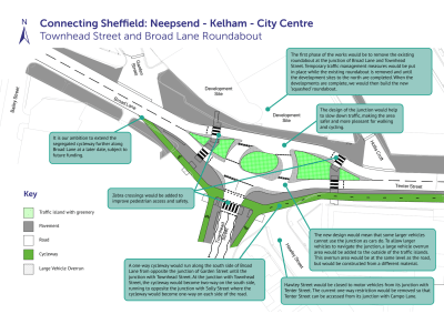
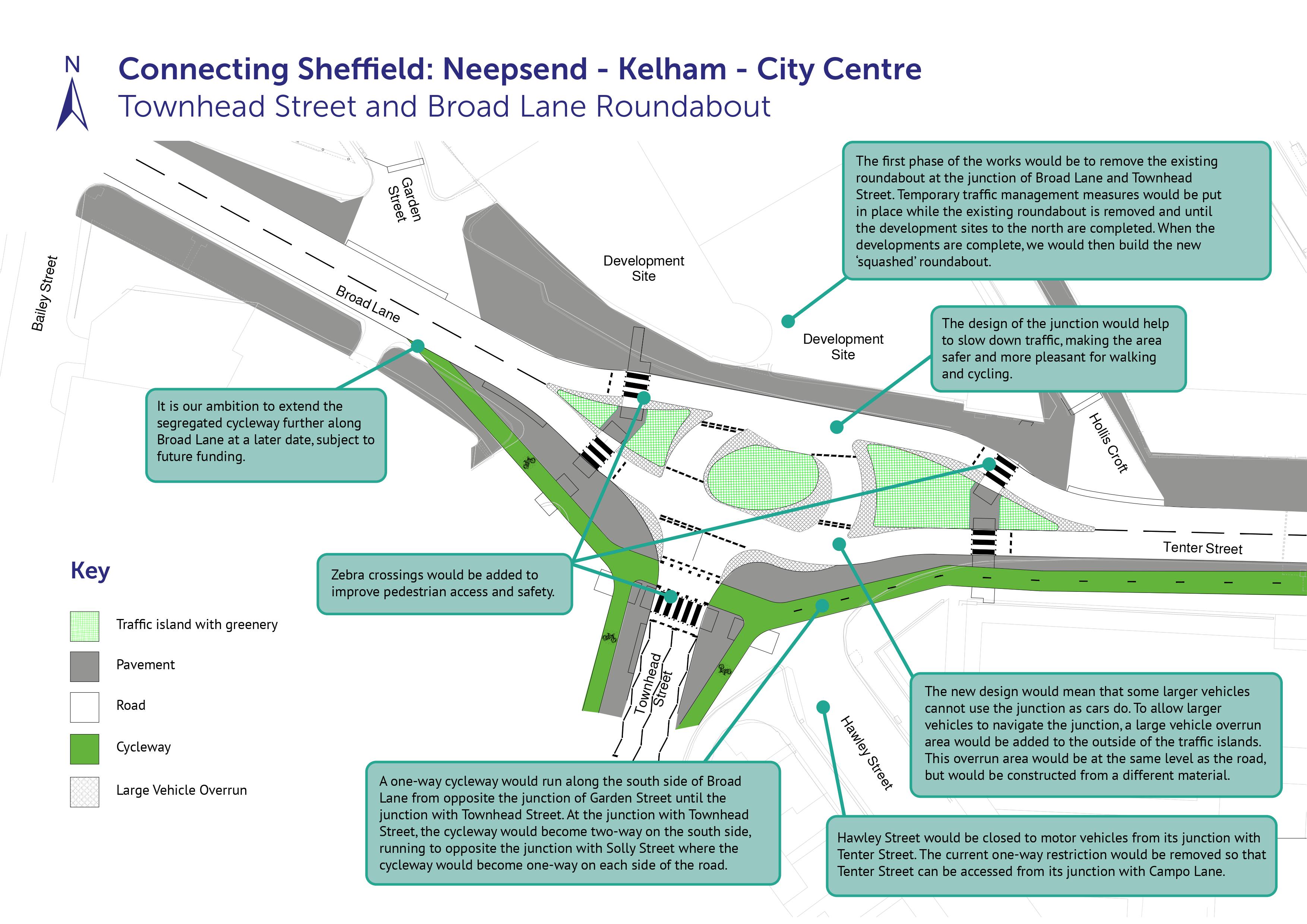
Phase 1 of the works will involve removing the central islands (roundabout) on Tenter Street, opposite Townhead Street which will facilitate early works to a development site on the northern side. The final design at this location has changed recently. The latest proposal is to create the City’s first dutch style ‘T’ junction / squashed roundabout which will reduce the speed of traffic, maintain all movements for vehicles but at the same time improve connectivity for active travel. The map below shows the new design of the junction. We expect the overall project to be completed in late 2024.
To view this map as a PDF, click here.
We’d like to thank businesses and residents in advance for your patience throughout. Our dedicated stakeholder manager Amber Hendy will be on-site throughout the work and is available on 07467 735 969 or via email at amberhendy@sisk.co.uk for any concerns or queries you have. If you are a resident on, or close to Tenter Street, please contact Amber Hendy by phone or email to be alerted about future night-time working.
You can also sign up for construction updates. Please email the project team with the subject ‘Sign up’ at hzncomms@sisk.co.uk
UPDATE 12 APRIL 2023
Thank you to everyone who has shared feedback on the plans for the Connecting Sheffield: Neepsend – Kelham – City Centre scheme during the latest consultation period. The consultation ended on Thursday 23rd March and we are currently reviewing and considering all feedback.
We are currently expecting a decision to be made on this scheme by the Transport, Regeneration and Climate Policy Committee around June 2023.
Introduction
In spring 2021, Sheffield City Council consulted on its proposals for the Connecting Sheffield: Neepsend-Kelham-City Centre scheme.
Kelham Island has become an increasingly vibrant and cosmopolitan inner-city residential district and visitor destination, and Neepsend is now following suit. The St Vincent’s Quarter around West Bar and Shalesmoor is also seeing new homes developed across the inner ring road, linking Kelham and Neepsend to the city centre.
Connecting Sheffield: Neepsend–Kelham–City Centre has been designed to reinforce and accelerate the development of Neepsend and Kelham, helping to improve the environment for those living in, working in and visiting these areas.
The scheme is being delivered by Sheffield City Council through the Government’s Transforming Cities Fund and is part-funded by South Yorkshire Mayoral Combined Authority.
It is being delivered in conjunction with the Kelham Island and Neepsend Parking Scheme which has been proposed to manage parking in the area. Currently Kelham and Neepsend has free and unrestricted parking which means it can be difficult for larger vehicles to get round (and deliver to) the area, but is also used for longer stay commuter parking. The area is likely to be attractive to park in for users of the new West Bar development too.
In response to representations from some local residents and businesses, and with around 1,500 additional properties expected to be built in the area over the next 20 years, the Council is proposing to introduce restrictions which means you’d have to pay to park in the area. The parking zone also helps to facilitate the Connecting Sheffield: Neepsend – Kelham – City Centre proposals. You can find more information about the parking scheme by clicking here.
The Connecting Sheffield: Neepsend – Kelham – City Centre proposals include changing the layout of some roads in Neepsend, making walking, cycling and public transport infrastructure improvements in Neepsend and Kelham and installing Sheffield’s first ‘Dutch-style’ roundabout.
You can find the initial maps, plans and proposals which were consulted on in 2021 by clicking here.
Changes following the consultation
Following feedback received during the 2021 consultation and a design review, we have made some changes to the proposals. An overview of the changes is outlined below:
- Removing the proposals for speed bumps on Russell Street and Green Lane. A recent review of these roads found that cars travelling along them do not travel fast enough for any benefit to be gained from implementing speed bumps. The continuous footways originally proposed here will be retained.
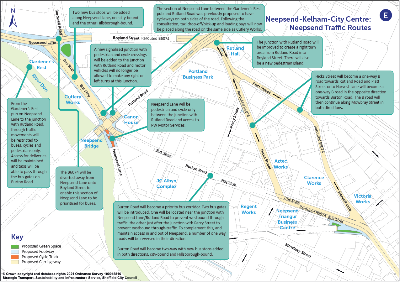
- Removing the proposals for cycleways along each side of Neepsend Lane between the Gardener’s Rest pub and the junction with Rutland Road. Instead the space allocated for the cycleways would be used for taxi drop off / pick up and loading bays which are needed by local businesses.
- The bus gate proposed at the junction of Neepsend Lane and Bardwell Road is expected to reduce traffic flows sufficiently to allow cycling in the carriageway alongside general traffic.
- Making the Dutch-style roundabout at West Bar into a perfect circle which makes navigating the roundabout easier and safer for cyclists. This was also following an independent review of the design, we will continue to have the plans independently reviewed as the scheme advances.
- The detailed design of the junction of Townhead Street and Broad Lane is currently under further consideration.
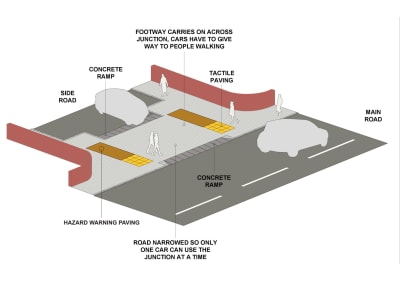
- There will now be hazard warning paving at continuous footways following consultation with disability groups. The hazard warning paving helps visually impaired long cane users detect that there is a crossing nearby and navigate safely to the crossing.
You can view updated maps with all of the changes below.
Implementation and Traffic Regulation Orders
We are proposing to start construction of the scheme in 2023.
Some of the changes that we’re proposing can only be introduced following the introduction of a Traffic Regulation Order (TRO). A TRO is a legal order which allows councils to change the way roads are used, such as regulating the speed limit, banning some turns, making a road one-way or changing loading and waiting restrictions – often indicated by parking bays or yellow lines. Once the order is advertised, there is a 28-day formal objection period and all objections must be duly considered before a TRO can be made operational
The TROs for this scheme were published on 23 February 2023. You can see the them at www.sheffield.gov.uk/home/roads-pavements/traffic-orders. (Go to drop down list and click ‘Proposed Traffic Orders’).
We welcome your comments on the TROs. The closing date for sending in comments is Thursday 23 March 2023. To send in your comments or suggestions, please email scheme.design@sheffield.gov.uk and put ‘FAO. Andrew Marwood’ in the email subject.
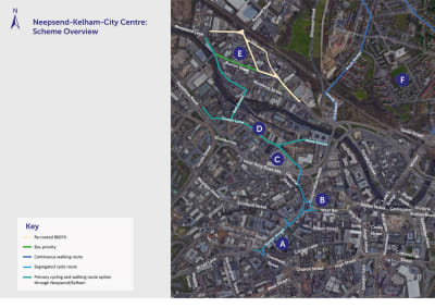
Maps and Plans
 Click here to see all maps as a PDF file.
Maps of the key areas where changes are proposed, along with descriptions of the changes, are provided further down this page.
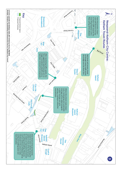
Neepsend and Kelham
A series of measures will see Kelham and much of Neepsend have lower traffic volumes making it easier and more attractive to cycle and walk and transforming streets into safer and more pleasant spaces that enable uses such as pavement cafes and events to take place.
To achieve these lower traffic volumes, the B6074 will be diverted so that traffic runs around Kelham and Neepsend rather than through it. The permanent closure of Alma Street and Ball Street to through traffic will also contribute to this aim. Vehicle access will still be maintained for residents, businesses and deliveries.
Some on-street parking spaces would be removed as part of this scheme and you would have to pay for parking on streets in the area. This is being delivered through the Kelham Island and Neepsend Parking Scheme.
The map below shows how the roads in Neepsend will be redesignated:
To view this map as a pdf, click here.
As well as reducing traffic levels in the area by removing through traffic, the proposals will give public transport priority which will make journeys by bus faster and more reliable. Improvements to bus stops will be delivered along with additional bus stops for the rerouted Hillsborough bound bus service along Burton Road.
Bus gates, which remove general through traffic in favour of bus access, are to be introduced along Burton Road, one at its junction with Rutland Road and Neepsend Lane to prohibit westbound through traffic, the other where Burton Road meets Percy Street to prohibit eastbound through traffic. Vehicles will still be able to use Burton Road for access to existing premises, however, with Burton Road becoming two-way to enable this.
When we consulted on the proposals in 2021, it was proposed that there would be cycleways along each side of Neepsend Lane between the Gardener’s Rest pub and the junction with Rutland Road. Having taken on board the feedback received and reviewing the measures, the space where the cycleways were proposed can now be used for taxi drop off / pick up and loading bays which are needed by local businesses.
Through the bus gate proposed by the Gardener’s Rest pub and with vehicles no longer being able to turn right from Neepsend Lane to Rutland Road, it is expected that Neepsend Lane will be quiet enough for cyclists to cycle in the carriageway and there still to be a significant safety gain.
A primary cycle route option would see people walk or cycle along Neepsend Lane from the junction with Rutland Road heading east, along Ball Street over the bridge via Lancaster Street and along Green Lane and Russell Street to the inner ring road and into the City Centre at West Bar.
The improvements for cycling and walking will continue from Green Lane along the Penistone Road service road to join up with the existing shared use footway on the A61. On Green Lane and Russell Street, we have removed the proposals for speed bumps on Russell Street and Green Lane. A recent review of these roads found that cars travelling along them do not travel fast enough for any benefit to be gained from implementing speed bumps. The continuous footways originally proposed here will be retained.
The proximity of Kelham to the A61 Inner Ring Road, Penistone Road, the A6109 starting at Savile Street, and Sheffield Parkway means that through traffic can be removed from local streets to more suitable routes to create an area where space is predominantly focused on pedestrians and cyclists. This will create more of a community feel in the area and provide a meeting place where people can spend time.
Rutland Road will remain in use to carry general through traffic between the A61 and Parkwood Springs, Pitsmoor and Parson Cross.
The map below shows the measures proposed for Kelham:

To view this map as a pdf, click here.
The measures above are designed to improve the environment for cycling and walking and to improve bus services through the area. The cycling routes will also connect into the existing Penistone Road cycle route, providing an enhanced connection between Hillsborough, Kelham and Neepsend, the City Centre at West Bar, and onwards to the Lower Don Valley.
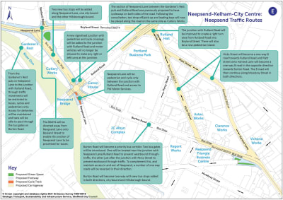
West Bar
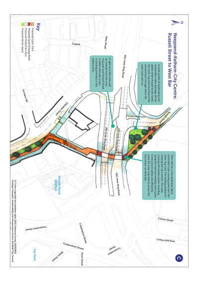
The improved environment for cycling and walking through Neepsend and Kelham will continue along Russell Street through a pocket of landscaping. The route will cross the inner ring road, supported by a new controlled cycle crossing alongside the existing pedestrian crossing as shown on the plan below.
 To view this map as a pdf, click here.
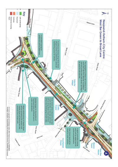
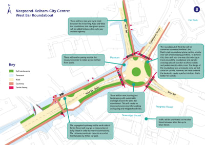
Landscaping, planting and new trees will be added along the routes around West Bar to provide an improved environment for walking and cycling. This will be similar to the Grey to Green approach used in other areas of the city centre such as Castlegate and will make key streets more attractive and create new green public spaces. Where possible, sustainable urban drainage will be integrated into the landscaping to support flood mitigation.
New segregated cycle tracks away from the main highway will be introduced where traffic volumes are higher between the inner ring road and West Bar and into the City Centre along Tenter Street.
The roundabout at West Bar will be converted to create Sheffield’s first Dutch-style roundabout which will give cycling and walking priority over motor traffic at junction crossings.
A segregated cycle track will run around the roundabout and pedestrian and cycle crossings will be positioned on each arm of the roundabout to make it safer and easier to cross the road. Dutch-style roundabouts are designed to reduce traffic speed much more than normal roundabouts which creates a safer environment for walking and cycling. Cyclists travelling around the roundabout will have priority over general traffic. Signage will be put in place to alert motorists to the changes in priority.
When we consulted on the roundabout in 2021, the proposal did not form a perfect circle for cyclists to navigate around it. Following an independent design review, it has been decided that the roundabout should form a perfect circle for cyclists as it is easier and safer for cyclists to navigate. We will continue to review our design independently.
As well as this, the segregated cycleway which is proposed to run along Tenter Street from the roundabout will now run up to Solly Street rather than the Hampton by Hilton hotel car park, as previously proposed. This will help to improve connectivity for cyclists.
Finally, it is no longer proposed to have soft landscaping outside the frontage of the National Emergency Services Museum. This is following consultation with the museum who need to retain access to their front doors. Instead, there will be hard paving outside of the museum.
The proposal for West Bar roundabout is illustrated on the plan below:

To view this map as a pdf, click here.
The photomontage below provides an indicative visualisation of West Bar roundabout where landscaping measures are proposed alongside significant improvements for cycling and walking. The improvements will provide much improved links between the city centre and Gibraltar Street for people living, working and socialising in these areas. The slider can be moved to show the viewpoint at present compared to the viewpoint after the scheme is delivered.
The scheme is being delivered by Sheffield City Council through the Government’s Transforming Cities Fund and is part-funded by South Yorkshire Mayoral Combined Authority.


The new segregated cycle track and landscaping will continue from West Bar roundabout along Tenter Street on the side heading into the City Centre. Tenter Street will become one lane in each direction for vehicle traffic. New signal-controlled crossings will be added to facilitate cycling and walking and a *continuous footway (see the details below for Burngreave and Pitsmoor for an explanation of a continuous footway) over junctions running off Tenter Street along the side streets towards West Bar roundabout will give priority to pedestrians. With the exception of Silver Street Head, access for vehicles to each side street and on Tenter Street itself will be maintained.
The roundabout currently in place at the junction of Broad Lane will be amended to provide a safer and more accessible route for cycling and walking into the city centre while also reducing traffic speeds. Vehicle access to and from Hawley Street where it meets Townhead Street will be removed, with Hawley Street becoming two-way with access from Campo Lane. The detailed design of what the junction will look like is still under consideration.
A future scheme will connect the cycleway along Townhead Street into the cycle tracks starting at Leopold Street that have been consulted on under Connecting Sheffield: City Centre.
 To view this map as a pdf, click here.
Burngreave and Pitsmoor Walking Routes - subject to further funding
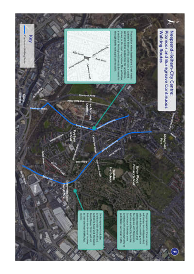
The proposals also included two new high-quality walking routes to connect communities in Pitsmoor and Burngreave with Neepsend, Kelham and the City Centre. The first route runs along Nottingham Street and Rock Street, the second along Burngreave Road and Spital Hill.
The routes are shown on the map below:

To view this map as a pdf, click here.
Where the northern section of Nottingham Street meets Rock Street, vehicle access will be removed to allow the footpath to run continuously across this previously existing junction. Alternative access to Rock Street and Nottingham Street will be via Andover Street.
Bus stops along Nottingham Street and Rock Street will be upgraded with high kerbs to make it easier to get on and off the bus, and shelters to protect people from the weather while they wait for a bus.
Measures will be implemented at all minor side road junctions open to traffic along these routes to give priority to pedestrians. The pinch point build outs currently in place on Rock Street will be replaced with full width road humps to better manage traffic flow.
A new pedestrian island will be created in the middle of Burngreave Road just above the junction with Abbeyfield Road, making it easier to cross the road to and from Abbeyfield Park and the children’s playground. The existing pedestrian island in the middle of Burngreave Road just to the south of Abbeyfield Road will be improved.
A number of *continuous footways will be introduced along the walking routes. Continuous footways are based on an approach applied in The Netherlands which gives priority to pedestrians at the approach to side road junctions rather than to motor vehicles as is currently the case.
Footpaths will run continuously across junctions at the same level as the pavement, and road traffic will have to travel over the raised footway via ramps to exit the junction. This will slow traffic down to enhance safety.
The visualisation below illustrates how continuous footways work:


Following consultation with disability groups, there will now be hazard warning paving at continuous footways. The hazard warning paving helps visually impaired long cane users detect that there is a crossing nearby and navigate safely to the crossing.
The continuous walking routes in Pitsmoor and Burngreave will be most ambitious walking routes in the city and will dramatically improve local walking connections and encourage walking in place of car trips for short journeys.
Check out the following documents